Monday, August 31, 2009
Riding to "Top O' the World" at Rollins Pass
Rollinsville to Fraser/Winter Park
Mountain bike, 40 miles each way
with Caleb and Tico
I feel like an old railroad man
Getting on board at the end of an age
The station's empty and the whistle blows
Things are faster now
And this train is just too slow
And i know i can walk along the tracks
It may take a little longer but i'll know
How to find my way back
-- "Railroad Man" by The Eels
Most Coloradans are familiar with the ski train from Denver, which goes under the divide through the Moffat Tunnel before screeching to a halt in Winter Park. Scenes of the ski train in Warren Miller films draw raucous applause from local audiences. Similar to the Eisenhower/Johnson tunnels near Loveland Pass, the Moffat Tunnel replaced an earlier route that went over the Continental Divide. This earlier route, built at the turn of the 20th century, went over Rollins Pass, also known as Corona Pass, and snaked 15 miles up from Rollinsville to what was advertised as "The Top O' the World." The top of the pass had snow sheds to protect the train from the elements and allow workers to keep the tracks clear of snow, as well as a restaurant and hotel. After the Moffat Tunnel was completed, the original route was abandoned, and is now a rough but scenic 4x4 road. But that's not all! The short "Needle Eye" tunnel just east of the pass partly collapsed in 1990, and has been closed ever since. (Apparently, this was due to a single missing rock bolt!) The closing of the tunnel is probably a blessing for mountain bikers, as it filters out motorized through traffic, which otherwise dominates the lower part of the route.
So, there's our history lesson. Caleb, Tico, and I had been looking forward to riding this route all summer, and finally arranged it for the last week of August. The weather was looking good, and the plan was to spend the night at Mike "Bailey" Bailey's house in Fraser, before heading back the same route on Sunday. Starting from Rollinsville, this meant 40 miles each way with our gear.
We parked near the "Public Restroom" (a port-a-potty) in Rollinsville, and began riding at 8AM. The first 9-mile warmup is a smooth, gradual uphill along South Boulder Creek.
After these first 9 mile, the rocky 4x4 adventure begins, near the East Portal of the Moffat Tunnel. There is a pulloff and parking area here for exploring the Portal, while the actual road begins a gradual switchback east. We take a quick break to fix a flat tire (our first of 3, with mine being the other two), and start heading up. The road here is very scenic, passing by several lakes, such as Jenny Lake and Yankee Doodle Lake, and nice pull-off camping spots. The last wisps of summer wildflowers are still evident. We keep an eye on the weather, with dark clouds forming in the West, but cannot predict which way the clouds will move. As it turns out, the pass itself ended up staying relatively nice, as the weather stayed pinned by the larger mountains to the North. Finally, around noon, we arrived at the Needle Eye Tunnel:
The tunnel itself is shorter than we envisioned, and is clear enough to get through, only there are 10-foot walls on either side preventing entry. Other parties are investigating the tunnel, including a mountain biking group from Estes, and a few 4x4 guys who walked up to check it out. In order to avoid the tunnel, one needs to make a steep hike above it. The mountain biking group has done it either way and considers it a wash. We decide to try it once each way, and head through the tunnel. This definitely only works easily with 3 people, with one on each side and one on top of the wall.
After the tunnel, it's even more fun, as we cross a few abandoned and rickety railroad trestles. The riding is actually smoother and flattens out a bit.
Finally, we reach the top -- the Top O' the World! The views are glorious, and we share the summit with the group from Estes. It's after noon, but it's neither storming nor raining. We take a lunch break and some pictures.
Coincidentally, at 11,600 feet, I wonder where my wife is. As in, how high she? You see, she started out just after 4AM with her friend DJ, hoping to hit the trail to Quandary by 7am. With the right conditions, they should have already enjoyed the summit and been on their way down. Still, there's a good chance she's still higher than me -- how awesome is that?
So now we get what we earned: downhill! The West side downhill is roughly 15 miles down to Winter Park. Make no mistake, this side is less rocky and more fun in both directions. However, the pine beetle kill here is evident, even with barely any sides of it on the east side. New spur roads branch off for forest-thinning work, and areas are routinely cleared to outflank the beetle's march, while new signs prohibit entry. We can imagine, though, that over time, new mountain bike routes will develop from this work, for better or for worse.
We cruise down over the rocks as fast as the bikes will roll...until I get my first pinch flat. My rear blows instantly and I slide to a stop at 20-some mph. After a fix and a few breaks, we finish the descent.
We ride partly on Hwy 40 and partly on the Fraser River Trail, eventually rolling into Winter Park. Back to "civilization," I suppose, as throngs of tourists squeeze out the last bits of summer from the mountains. (OK, that's what we were doing, too!) Turns out this weekend is also the last race of the Winter Park Mountain Bike race series, the Tipperary Creek route, which is coincidentally the only other ride I've done in Winter Park (as a ride, not a race).
We finally roll into Bailey's yard around 3pm, 7 hours after our journey started. We sit on the couch in a daze and he offers us some beers. We're happy to sit and catch updates of the Twins and Tigers scores, partly napping and eventually showering, before heading out for dinner. We lightly debate Mexican versus pizza, as Caleb and Bailey previously scouted out the food scene and assure us we can't go wrong either way, so we settle on a Mexican-sounding pizza place: Hernando's. The pizza...is...awesome!...The thick crust and salty cheese especially. Basically the perfect food at the perfect time. Hernando's is decorated with the colored dollar bills of patrons, and can get crowded, but luckily we're there with our ravenous appetites closer to senior hour.
We grab some extra food from Safeway, then head back to chill out, playing around with the house dog, Jackson, and playing a game outside which is variously called "Ladder Ball" or "Dangle Balls," which I will refer to as the former ("Ladder") in order to suppress giggles. While outside, the sun sets, and the mountains exit the eastern stage in alpenglow. We catch the end of a televised Texas high school football game -- my, Texas, what large high school stadiums you have! -- before heading to bed early. I claim the futon outside, and sleep quite comfortably in the alpine air, glad that I brought my sleeping bag.
We awaken before 6:30 as Bailey heads out to work, and we start rolling again by 7. After a quick coffee stop in Safeway, we start rolling, and feel surprisingly fresh compared to the night before. Caleb spots some wild raspberries off the edge of the road, and we stock up on antioxidants, just in case we encounter oxidants.
Soon, Winter Park is below us again:
We take a steady pace up the road, and quickly reach the bottom of Riflesight Notch trestle again. Caleb heads up the road, Tico decides to try the steep singletrack. I head up the road so Caleb knows to wait, but secretly think the singletrack might be better. After catching my breath at the top, it turns out the road is indeed faster. We check out the trestle for a bit and meet some bow-hunters who just came off of Roger's Pass trail. We look at the map and think about Roger's Pass across the divide as an option, but decide against it since we don't know the terrain. Next time?
We make good time up to the pass, and the weather still looks good, so we hang out a bit more. Some skiers have parked up the pass and are hiking to a glacier -- nice to get turns in August! Tico and I head to a nearby snowfield to check it out, then we make our way down.
Again we hit the trestles, which are more scenic in this direction. I take a short video and some pictures.
We hit the Needle Eye tunnel again, and decide to go over this time. This ends up being significantly more work, as the West side especially is steep and affords little purchase for the gentleman hoisting his bicycle up the rocks. On the other side, as we adjust our gear, we're greeted by the echoes of gunshots. Welcome to the Wilderness! We spot a likely shooter below us, and it looks like he's plinking down there, not shooting upward. Hopefully.
We descend the rocks, and today's word of the day being "Adit," we check out an abandoned mine. Caleb takes some samples and suggests that they may have been seeking mica.
We continue descending, sure to make it by 2:30, when Tico wants to get back to the car, until I get another pinch flat! Final score: Mike 2, Caleb 1, Tico 0. Yargh. Although I ran a bit higher pressure today then yesterday, it still appears I was too low, at least with having an extra 20-30 pounds of gear and pounding over rocks and potholes. In fact, I bent the bead of the rim, and we're unsure if the tire will seal. Luckily it does, and I'm more cautious on the way down. Finally we get off the rocks and back onto the road, which somehow was uphill the whole way there but is now rolling. So it goes. An overly cautious car waits to pass us, then some jerk dirt bikers make it 3 abreast on a blind curve. No doubt they're in a hurry to make their shift as emergency surgeons, to volunteer at a puppy rescue, or defend their PhD. theses, so I wish them godspeed.
And so it goes as we make it back to the trucks, at 2:29.30PM. Tico is off to sell beer at a Broncos game, and Caleb and I head back to the Fort. A good time was had by all.
Thursday, August 27, 2009
Baretooth and Horsefoot
I hadn't seen my friend Ben for a month and a half, as he was busy hitting all the midwest hot-spots for a few weeks: Twin Cities and Alexandria, MN; Iowa; and Chicago, if I recall correctly. In the meantime, though, he started reading "Born to Run" and also started running barefoot. I'm a big fan of both of these, though Ben had a few more good ideas which he's been up to: making your own duct-tape sandals (cool idea and very comfy!), and speed jump roping barefoot. I'm going to consider these for fun projects and training.
Anyway, earlier this summer, we had a few Thursday mornings of running up to Horsetooth. It had been awhile, so I was hoping he was game for it, even though CSU is back in session and he had a morning class. Luckily, time of day doesn't seem relevant to him: as long as it's fun and he can fit it in then he's game, sleep be damned! I feel the same way, except for the sleep part catches up with me more quickly in my old age...
I rode out from my house just after 5am. Now that August is almost over, that's entirely before dawn. Most people might curse being up that early -- including myself for most of my life -- but instead I cursed myself for not doing this more frequently: the stars were clearly visible; traffic was non-existent; the humidity was higher than it is after sunrise, and, coincidentally, the scents of plant life. I acknowledged a fox that crossed the street. As I rode, the Eastern sky lightened subtly, a glorious gift from a direction that otherwise merely provides the odor of livestock. Upon reaching Ben's house, and heading up to Horsetooth, the sun cleared the horizon, and not a cloud was visible in the sky. For some reason, this surprised me: the idea that you can't really tell just how clear it is until the sun is up. And this is just a plain Thursday -- 27 August 2009 -- that will never happen again, yet will happen always. I try not to take this magic for granted, but regret how many weeks pass between viewing of sunrises. I can't help but think of "Johnny Got His Gun", where the blind, deaf, faceless, quadruple-amputee Joe Bonham begins to mark the days as he feels the warmth of the sun on his skin. While he ultimately pounds out a frantic tirade against war, I also see him as trumpeting the beauty of the natural world, and the simple blessing of a sunrise. Here, we have the convenient excuse of being a "morning person" or no, but who, given a week to live, would not awaken for seven sunrises? Given a month, I should hope to choose the month, and see 31.
Back to this Thursday, or today's impression of one: Ben suggests we at least try running some of the trail barefoot. First, as a lark, but also (and perhaps more importantly) because his Facebook status said so! A plan committed to Facebook is a plan committed. The bottom of the trail, however, is just the right kind of wrong rockiness: medium-shaped stones that are too prolific and have strategically dispersed themselves across the trail, so we begin in our shoes. After the initial few turns, though, things clear up a bit, and we try a few hundred yards barefoot. Conversation ceases, breathing changes, and we both pick lines of self-preservation between rocks. A fun experiment, to be sure, but not sustainable, so we put back on our shoes and crank up the hill. We do find one more forgiving spot, in the shade just after the branch of the Horsetooth trail coming off of Soderberg, and we make it a bit further, including an occasional stretch of blissfully rock-free sand, which reminds us how running in shoes also doesn't convey temperature. Overall, we might have gotten a quarter-mile of barefoot running in total.
We put our shoes back on and headed to the top. Here, I should point out that we saw nobody on the trail, and this is my 7th or 8th time up top without any other parties, on perhaps Fort Collins' otherwise most popular trail, at the best time of day.
Thank you, Thursday.
We enjoy the view, pick up some leftover fireworks, and bomb down the hill, more often than not at speeds at the nexus of 'fun' and 'utterly reckless.' I sprain my ankle slightly, but fortunately run it off, focusing on keeping my foot pointed utterly straight, and we finish out the run.
We head back, I grab my bike, and head through campus with some time to spare. Unwittingly, I head past the track, and see some sort of women's calisthenic program, along with a few joggers. With some time to spare, I decide to try a barefoot lap to see how the track feels on my foot. 400 meters later, I have my answer: fantastic! At the start/finish line, I decide on one more lap, after glancing at my watch, to see how fast I can run barefoot. Up until now, I have no idea, and I submit to you, dear reader, that the normal internal clock is uncalibrated for the slightly increased focus and concentration required for barefoot running. I finish the next 400m, at pretty much the same pace as the first, and have my answer: something in the high 1:20's. Feeling great, I figure, why not finish the mile? Why not, indeed. The next splits are all in the 1:20's, and I'm even capable of a kick on the final backstretch. I'm not big into numbers themselves or being prideful, but I'm pleasantly surprised that slapping my feet barefoot for a mile takes less than six minutes. To this, I will add that I felt less out of breath than I would have in shoes, but my feet and calves were a bit more fatigued. So, not only is running barefoot fun, but it also might just figure into good speed workouts in the future, which might help my overall form.
Plus, good for the soul!
Tuesday, August 25, 2009
Thursday, August 20, 2009
List of Mountain Passes Ridden
As I remember them:
Paved (Total ride for that day exceeds 100km)
Cameron
Iceberg / Trail Ridge
Fremont
Tennessee
Hoosier
Battle Mountain
Vail
Loveland
Ute
Hardscrabble
Unpaved
Georgia
Kenosha
Schofield
Paved (Total ride for that day exceeds 100km)
Cameron
Iceberg / Trail Ridge
Fremont
Tennessee
Hoosier
Battle Mountain
Vail
Loveland
Ute
Hardscrabble
Unpaved
Georgia
Kenosha
Schofield
La Plata Peak: 1st 14er with J
La Plata Peak
1-Aug 2009
with Jessica
9.4 miles
Earlier this summer, Jessica surprised me by saying she had been wanting to climb a "14er", or one of the 54 (more or less) 14,000+ foot mountains in Colorado. Thanks, in no small part, due to my brother-in-laws awesome pictures and description of an early summer snow climb of Longs Peak. Nevermind that she and I never talked about doing (nor even really heard people talking about, other than Whitney) the 12 in California when we lived there...plus a host of others in Mexico, Canada, and Alaska, just to cover North America. As for Central and South America, heck, she was walking around 12k feet in the ruins of Cusco without any special significance. Arbitrary numbers, all. Still, it seems to be a Big Deal in Colorado, probably because one beautiful state hosts so many gorgeous peaks. I thought it was fun to ride up Mt. Evans a few years back, but that was mostly the unique novelty of pavement at 14k feet (and 27 miles of climbing -- ho ho ho!) There are various records loosely kept involving fastest and youngest to "bag" all of these in one season, as well as more unique goals involving ski descents and self-powered visits of every peak. For that reason, summer weekends in Colorado result in dozens or hundreds of people all climbing the same peaks, while nearby "lesser" mountains remain pristine. I've heard and seen nightmare pictures of anthills crowded with people on the standard routes of Front Range mountains, with enough screaming kids, ringing cell phones, jeans and t-shirts to make a mountain seem like Walmart. No thanks! I still feel melancholic when I think about our first and only visit to Yosemite, a place that I dreamed about as the epitome of the "outdoors," only to see crowded lines of cars snaking across the valley floor.
I'm not covering any new ground with these arguments, and it's a Catch-22: It's great to see and promote exercise and enjoyment of nature, I'm just hoping (also) for respect (of other users, and the mountains themselves) and LNT as well.
That said, I was excited to hike one with her, and excited by her enthusiasm, but only if we hiked a non-standard Class 2 route on a non-Front Range mountain, since we would be going on a weekend. That is, not too easy, not too hard, and not too crowded. And, this would be after we did sufficient previous warmup hikes for training, which secretly doubled as good altitude ultra training for me! All of this went well, and we had an enjoyable month of hiking. So I started reading online forums, looking at pictures and routes, and picked up a copy of Gerry Roach's classic. Some friendly folks online suggested La Plata from West Winfield, and it was settled.
We left Fort Collins late -- I was unable to get out of work early -- and made it to Co-390 just after 10pm, after driving through a steady downpour from Frisco down through Leadville. We found an empty pullout on the road, moved gear around, and slept in the car. Just after 5am, with stars but few clouds in the sky, we started getting up, got ready, and drove a few miles to the trailhead; in our case, just after the rough 4x4 road started past the Winfield cemetery, 1.2 miles from the TH. It turns out we easily could have driven the rest of the way, but I didn't want to waste the time finding out, and it wasn't a bad warmup on flat road. At 6:45AM, 3 parties of 2 were ahead of us, and another just starting. We saw the other parties on the way up, but we were still relatively dispersed. The hike from the TH began through dense forest and wildflowers along a creek, very scenic and shaded. Quickly the view opened, and treeline was achieved. After this, we were treated to a wide-open meadow, surrounded by mountain ridges. The meadow, however, included muddy willows, still wet from the previous night's rain, so our feet were already wet just a few hours in. After weaving through the meadows, we approached the most fun part (in my opinion, though opinions vary) of the hike: a switchbacked, steep climb on dirt and scree up a headwall. At the top of this, views were incredible from both sides, and we had a gorgeous tundra ridge-walk towards a boulderfield.
The boulderfield, by unanimous opinion, was not the most popular part of the hike! Last night's precipation up here was formed as snow and ice, still sticking to the rocks. As a broad ridge, there was no imminent danger, just slow going as we picked our way up the rocks. We followed previous parties to the climber's left of the rock, but upon descending, I could confidently suggest staying towards the middle or right, looking for trail and avoiding boulders as much as possible. At the top of this section, which took an hour itself, we were treated to more views, a shifting wind, a false summit which I read about, and a couple getting ready to descend. I asked him about what lie ahead, and he responded, "After the false summit, there's another false summit...and just when you think you're there, there's one more summit!" Fortunately, this situation was almost exactly similar to the northeast ridge of Clark Peak: I knew Jess wasn't a fan of false summits (who is? it's like trick birthday candles...or something), but at least I could relate it to something we've already done. Anyway, so there was more boulder and rock, ungulating toward the top, though the boulders here were easier to stay on top of. Eventually, we crossed paths with an unstable female runner in shorts who asked which way down (probably doing a long out'n'back or loop from the other TH), and we mixed with heavier traffic from the standard trail.
Finally, the summit was achieved! Conveniently, the wind on top was almost non-existent, compared to the ridge below. There were around 8 others or so on the fairly small summit, kind of crowded but everyone had their own space. We met some friendly folks, took pictures and received some in return; counterbalanced by one guy conducting some sort of lame business on his cell phone, and a Boulder uber-couple plotting out their other 14ers in the coming weeks (hey, what's wrong with enjoying *this* one?) After about 10 or 15 minutes, eating breakfast burritoes and taking in the view, we headed back down. The sky was still very forgiving, so we took a break after the boulderfield in a marmot-inhabited meadow, enjoying the sunshine and easier trail. Then, we headed down the headwall, where I had a chance to test my new Brooks Cascadias in a combination of running and scree-skiing (basically, running the straights and sliding into the turns), and I had a blast! Jess didn't enjoy it as much, in tennis shoes, but we'll see next time now that she has hiking boots. By the time we hit the willows, some of the mud had dried out. We stopped again for pictures at the bottom, and got back to the car at 2:30, 8 hours after we started, with maybe an hour of breaks total.
A perfect day on La Plata! And I'll admit, now, that some of the excitement started creeping in, replacing some (but not all) of my weariness and reservation about crowded hiking. It is exciting, I'll admit, to see pictures and stories about specific mountains, which is a byproduct of their popularity. My hats off to those that do all of them, and I hope (and suspect) for many that do them, that's half or a quarter or less of their total hikes in Colorado. In other words, they're doing them in the course of doing all kinds of different mountains. What I'd like to caution against is people that live here, or those that visit from out of town occasionally, and only hike 14ers, by the quickest route possible, on summer weekends: you're doing yourself a disservice by not exploring the other fine options this state has to offer, in all seasons. We loved La Plata, and highly recommend it, but also agreed that Blue Lake/Clark and Pawnee Peak in IP, both <13k feet, were even better. I have no intention of going out of my way to hike specific mountains or not based on their elevation or lack thereof, but there are certainly some beautiful hikes and climbs that are intriguing and I don't want to miss (Chicago Basin, Willow Lake approach, Holy Cross, to name a few), and maybe some of the closer ones by moonlight or by snow. And if Jess, or anybody else going along is stoked too, even better!
Wednesday, August 19, 2009
Fort Collins Duathlons
List of FC Duathlons (Stats to be updated over time)
All distances are round-trip, roughly from Old Chicago on Harmony and Timberline
Bike/Trailrun:
* (FC) Coyote Ridge/Blue Sky/Devil's Backbone
* (FC) Horsetooth MP
* (FC) Bobcat Ridge
* (FC) Reservoir Ridge (or any Foothills Trail access point)
* (FC) Round Mountain
- 9.5 miles trail
* (FC) Redstone Canyon
- Run: 18 miles hardpacked dirt road
* (Loveland/RMNP) Stormy Peaks from Dunraven TH
- Ride: 67 miles road/concrete, 5 miles hardpacked dirt (Dunraven Glade Road)
- Run: ~20 miles trail
* (Estes/RMNP) Twin Owls/Black Canyon
* (Estes/RMNP) Lawn Lake
* (Boulder) Chatauqua "FC Super Double Mesa"
- Ride: 100 (an extra couple miles scrubbed to make it even!)
- Run: ~13 miles trail
Bike/Ski
* Horsetooth MP
* Foothills trail/Dixon Lake
* City Park
Labels:
bobcat ridge,
duathlon,
road bike,
ski,
trail run
Tuesday, August 18, 2009
Stormy Peaks Duathlon via North Fork Trail
9-Aug-2009
72 miles road bike from house (~4900 ft)
~20 miles trail run/hike to Stormy Peaks (~12200 ft)
11 hours total
I was finally starting to feel recovered from Leadville, anxious to run somewhere in the mountains again, and the weather was looking good. And, ideally, I wouldn't have to use the car.
Earlier in the week, there was a bit of discussion on the FC trailrunner list about Comanche Peak wilderness. While I'm more familiar with the north/Pingree Park/Poudre side of Comanche, someone mentioned the North Fork trail as being a good option. In this case, the North Fork being the "Big T", a river which I've ridden next to countless times and have awe and respect, but don't have much experience with the river away from Hwy 34.
Here, I'm going to jump ahead to get the negative part out of the way, so that the rest of the story is all positive. I arrived back at the trailhead about 4.5 hours after starting, longer in time and distance than I planned but a fun route overall. My bike was happily unmolested and the tires were full of air. After a quick shoe change, I bombed down the dirt road on the road bike, ~30mph with barely room to think. I honestly think I was more aggressive mainly because I had just been running, slowly, and it was nice to cruise without pedaling. I almost lost it on the last corner, as there was too much sand in the corner to brake comfortably, but I needed to stay on the road! Luckily the skinny tires held up and I was on my way. As it was now mid-afternoon, some clouds were threatening from the west, so I tried to 'hurry', as much as I could. The rain held off in the canyon, but not the idiots: a gaggle of tourists were pulled over for bighorn sheep pics, including one minivan parked into the shoulder/traffic lane (with the family still inside, taking pictures, too lazy to park legally and walk); shortly after that, some guys went by thinking it was funny to blast an airhorn at riders as they went by. I made it to Loveland without rain, but then lightning started coming, with a mile to the East. Again I hurried, and on one of the country roads, with no other cars and myself hurrying to avoid lightning on the edge of the road, a car honked at me and tapped the brakes, unsure of how to share the road competently with some guy trying to stay out of the way and get home safely to his wife. So after a fabulous day, I was in a bit of a foul mood. I think many of the anti-cyclist motorists really cannot fathom riding a bike on the road, and believe that only people on a bike stand out as inconveniencing their ride for entertainment, not admitting that they themselves are nearly all of the time driving for fairly useless errands. They lack the experience and imagination to realize that I very well could have driven a car to the trailhead instead, at the cost of clogging the road up even more as well as other negative economic externalities (increased road/maintenance cost, pollution, statistical accident threat to them). Why not honk at all the joyriders and tourists clogging up the road instead? Or people driving a few miles every day to work? Because somehow skinny guys on skinny tires and 20 pounds of bike stick out more and are easier to harrass. I'm not trying to prove any point or anything, I pose no risk and just want to be left alone to ride safely, I just like to ride my bike and stay the heck out of the way.
***
Back to the beginning....
The ride there was fairly uneventful, I strapped most of my extra weight (trail shoes and clothes) under my seat, and this kept most of the weight off my back. I arrived at Dunraven Glade Rd in a couple hours, and finally got a chance to ride something new. I knew it was a couple miles or so up the road, and I vaguely recalled that it was an unimproved road. Well, it's a 2.3 mile grind up a hardpacked, washboarded dirt road, and I couldn't even muster double-digit speeds. Given the choice again, though, I wouldn't hesitate to bring the road bike, as this was only a small part of the ride. Still, it slowed me down from my estimated run starting time, as well as fatigued my legs more than I anticipated. But I arrived at the trailhead, which has a restroom and a lot that was full of cars and no bike rack as usual, but I hitched to a wooden fence by the trailhead sign.
Generally, the beginning of the trail is nice and shaded, friendly and accessible to families to take a stroll in the woods, as well as horseback riding. I'm not a horse guy, but if I were, this is a pretty good spot with the shade and lack of mt. bikes, and every horse group I encountered was polite and respectfully yielded the powerful but slower horses. Otherwise, this trail is a nice but longer backdoor entry into RMNP. It's about 4.3 miles to the RMNP boundary, and beautiful uncrowded campsites line the trail. Most of the traffic at this point, if any, are friendly backpackers. Of course, along the way is the Big T as a reliable water source. Continuing on, one can hear the rumble of Lost Falls, and shortly thereafter, just over 8 miles in, reach the fork for Lost Lake or Stormy Peaks. Note that the otherwise reliable and enjoyable "Afoot and Afield" pegs the Lost Lake trail as a 14.3 mile roundtrip, but this cannot be correct. As another aside, it is my observation that "Lost Lake" and "Blue Lake" are the two most common lake names in Colorado.
Anyway, it appears that the (left) fork to Lost Lake is more popular as a backpacking destination, but I wanted to hit tundra, so took the right fork to Stormy Peaks. The pass is designated as 1.6 miles from the fork. Quickly, the trail steepens and switchbacks up above treeline. While a bit rockier, the trail is in great condition, and was being worked on by three young men that had obviously hauled equipment quite far onto the trail. They were tarp camping and had some beer in the river: what more do you need?
Anyway, the open views into RMNP were stunning, and South Stormy Peaks campsite was the best one of all. I slowed to a fast hike and hiked up to the pass. Here I saw a party of 3, but they were heading to the south for more views. Stormy Peaks are the higher points to the right, so I just headed straight up some boulders to the top. I was rewarded with even better views of both RMNP and Pingree Park, some wind, and a new summit register. Just a few people seem to trickle in every weekend, plus a large party from Wausau, WI (just typing that summons forth the smell of the paper factory when driving throuh that town, but I say that fondly as it was a gateway to going "Up North" as a kid). After some time up top, I headed back down, and found the trail to be quite runnable in this direction (meaning, I was too tired to run up it, but it's quite pleasant to run down).
I stopped at Lost Falls to refill on water, and I met a friendly backpacking couple, Justin and Allison (sp?) from Nebraska. Justin had been coming here for quite some time and said it has gotten busier/more popular, though even I couldn't complain about the crowds. I only had my UV steripen, he offered to let me use his filter, but I wanted to continue the 'experiment' with the steripen only (and my bandanna 'pre-filter') so I knew if it worked on the 3 liters I tried. (Now that it's been over a week, I'm still happy with the results). They were staying until Monday and looks like they had a great weekend of weather. My water gathering and break took a little longer than expected, but soon I was back on the trail for an uninterrupted stretch of a few more hours of running. It was still quite pleasant in the shade and I wasn't in any hurry. I passed a solo hiker and spaced out a bit, as right after passing him I biffed on a small rock, slid forward and dropped my bottles. He asked if I was OK, I was mostly embarrassed at having a witness!
Anyway, all told it was a great ride and run. I look forward to returning and exploring Lost Lake someday.
Monday, August 17, 2009
DP with BFM
Sun, 9-Aug
Diamond Peaks (South Diamond)
with Jessica
~3.5miles RT
10,200-11,800
~3 hours (including summit goofing off and bushwacking)
We got a late (8AM) start, but it was nice out and I wanted to get above treeline. So, we took a leisurely ride to Cameron Pass. Diamond Peaks are well known for fantastic backcountry skiing, but not as popular for hiking. It's a shame, but it also meant we'd get a quiet hike.
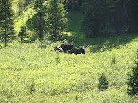
Our original plan was to hike up to Montgomery Pass, follow the ridge to the Diamond, descend the DP trail to CP and return via the Cameron Connector trail. Once we arrived at the Montgomery/Joe Wright trailhead, though, the fierce North wind made me decide that having the wind to our back on the ridge would be a better bet. Still, this was a good spot for a potty break and a moose sighting!
We continued up to the Cameron Pass lot and started up. The summer trail is barely defined, but essentially follows a small gully straight up. It's not much more than a mile to the top, and, if motivated, someone could get up there in 20-some minutes.
This means it's steep, but also has a quick payoff for the effort, with gorgeous views all around. We followed a faint trail to the saddle between the 2 peaks, then traversed along the leeward side until the windy, cairn-marked summit:
On the summit, we had expansive views in either direction.
Feeling confident at a shorter hike in a familiar area, on a bluebird day, we relaxed by ourselves and enjoyed lunch and beverages.
Amazingly, descending 20 feet or so put us out of the wind into a completely calm summer day. I was also intrigued by the long obvious ridge stretching out parallel to the Poudre, and we enjoyed spotting Clark Peak as the highest along the ridge, having done that together from Blue Lake last month. We proceeded along the ridge, then decided to cut down below a snowfield along a trail, looking for passage into the woods. Suddenly, I saw motion, as a BFM trotted within 15 yards of us, directly across the most obvious trail along the top of the forest! It was neat seeing them earlier from a distance, but not by ourselves in the middle of the woods. Luckily, he was completely disinterested in us and kept moving. But, that meant we had to backtrack or head straight downhill. We decided to bushwhack straight into the woods, giving enough space between us and the BFM, before proceeding back along the contour of ridge. I knew there were a few intermittent stream crossings, and once we found one, it was easy to follow it all the way down. We found the blaze of the Cameron Connector, and followed it most of the way back, skirting a few swampy meadow areas. There was still an impressive wildflower display near the river, though clearly the peak had passed.
All in all, a good time was had by all.
DP is on the list for quick access to tundra, solitude, wildflowers, and meese sighting.
Hope Passed, for Now...
Hope Pass Hike
Winfield/Missouri Gulch
Sat, 15-Aug
with Jessica
~5.0 miles rt, 10k to 12500, ~3 hours total
Originally, we talked about doing the Stonewall Century this weekend, but decided against it due to general lack of interest (for now). I had been wanting to do this ride since my friend Will told me about it a few years ago, and it fit the bill of the kind of organized ride I like: scenic, affordable, fair amount of climbing, small-town feel, and far enough from home to justify driving there to ride some different roads. I was a bit bummed to hear that this was the final year, but I have sense learned it will be back next year (with a new director) -- huzzah!
Instead, we looked at another hike. We can't get enough of the Sawatch, so we decided to return there. Problem was, weather was fairly unsettled across Colorado for the weekend. It looked sucky for sure in the Fort, at least for Saturday, so it would be nice to leave. Still, I ruled out some longer, all-day hikes to minimize suffering due to weather. I was still hopeful that we could do Huron Peak from Lulu Gulch. The question is, would the weather cooperate?
The answer was mixed. Heavy rain was predicted through midnight Friday night, and then some clearing and lower probability (but still ~30%) for rain. This wasn't too far off the same forecast for our last couple of trips near Leadville, which ended up having decent weather most of the morning at least. We were both kind of tired from work, and I was unable to leave early enough, so we decided to set the alarms for 2 and head off in the morning. One concern, though, was driving right through the start of the Leadville 100 Trail Race (mt. bike), which started at 5:45 AM with a fairly sizeable field, spectators, and a guy named Lance.
Luckily, this part of the plan went off without a hitch. We got into Leadville at 5:02AM, which means that "Provin' Grounds" was open with fresh coffee! I refilled my cup and headed out of town, careful to avoid light-less racers warming up on the road, and just got through before they closed Main St.
Did I mention it was 38 degrees and rain/snow over Fremont Pass?
From Leadville into Chaffee County, though, the weather cleared and I could see stars, along with a barely brightening Eastern horizon. Going down CR-390, though, there was a decent amount of fog, but also consistent dark clouds and rain sitting in the valley.
Still, we parked at South Winfield and headed up toward Huron. The trailhead and camping spots were noticeably less crowded than a few weeks ago, but still a fair amount of traffic. Once we split off the main 4x4 road up toward Lulu Gulch, though, we didn't see anyone else. But, that's also when we heard thunder, at 7AM.
Bad news.
It was distant enough and we were still well within treeline that we held out hope it would clear up. Instead, the rain intensified, and the temperature dropped. Also, this peak is known for phenomenal views, being distant from paved roads and all -- would it be worth it to get up there -- cold, wet, and anxious about storms -- only to see more clouds and rain?
We turned back and headed for the car. Discussing our options, we decided to sleep in the car for an hour or two, wait out the weather, and check on our options. I had a backup plan to hike Quail Mountain, so we headed to that (empty) trailhead, and napped.
Around 9:30, the sun was out among puffy and fast-moving but still non-threatening clouds, so we headed up Sheep Gulch, an original (but now bypassed) part of the Colorado Trail toward the saddle between Quail Mountain and Hope Mountain. I didn't know it at the time, but the pass over the saddle is Hope Pass -- the high point near the middle of the Leadville 100 Trail Run.
Also, Quail Mountain itself has been studied in the past to be developed as a ski resort. Since I've fallen in love with that area, I'm glad this nightmare never came to pass (apparently, the yearly snow totals were too low).
The trail has a steep immediacy, but is very well constructed and proceeds through dense aspen.
As we climbed, some new clouds rolled in, and moderate rain started falling, turning into small hail. We could see bits of blue to the West, and the clouds were moving fast...we waited about 3-4 minutes under tree cover, and sure enough, the rain stopped. We continued over some rockfall,
which looks like a fun way to approach toward Hope, and eventually broke out above treeline, revealing fabulous views of Missouri Gulch.
Keeping an eye on the weather, we headed up switchbacks towards the saddle. I put on extra layers before reaching the top, bracing myself for the inevitable blast of wind that comes over the Divide. Jessica joined me for a windy pic at the pass:
We took in the great views, but not for long. We decided not to climb Quail Mountain, but instead head back to treeline, as the clouds continued to threaten from the southwest.
Waves of clouds came in, but no storms. Interestingly, the weather seemed to swirl around the valley, staying mostly blue on the side above Hope Pass, and mostly grey above Belford/Oxford/Missouri/Huron. As we descended, we checked out a cool abandoned mine, that was wide enough for further exploration, but not by me, not today (La verdad: tengo miedo del muqui!)
More clouds came in but still no rain. We saw our first and only people, a friendly couple, exploring the bottom part of the trail: all in all, a great hike for views and solitude. At the bottom, we set up camp down the road, took a nap outside, and grilled up veggie burgers and corn for lunch. We hung out the afternoon reading and napping, and the weather held up, but we decided to head back that night. After, of course, a mandatory stop at Eddyline Brewpub in BV!
Hello World
Let's try this again.
This is going to be my place for trip/route postings. I'm starting to get old and stuff is beginning to blur together.
Subscribe to:
Posts (Atom)