Sunday, July 31, 2011

A Night in Kansas: Coleen's Sweaty Ass

"It's not so much the heat, as it is the gosh darn humidity"
-Bananas at Large, "Da Turdy Point Buck"

My last long run for Leadville training, essentially, found me running in circles in the middle of the night in the Kansas prairie.

Leaving Colorado for a flatter, lower elevation trail run in preparation for an ultra at 10k feet may seem counterintuitive, but based on circumstances, it was a fantastic and fun choice. J and her friend Jenny had signed up for the WIN for KC triathlon in Kansas City, so we had a quick weekend trip planned to see Jenny, her husband Tom, and their two adorable and energetic young boys. Meanwhile, 3 weeks out from Leadville, I was looking for some trail running for the weekend.

Enter Coleen's Sweaty Ass.

Most trail runners are familiar with the concept, but a Fat Ass run is an organized, disorganized, timed or not timed running (when you feel like it) non-race race of arbitrary distance or time, or neither. In short, it's a gathering of folks that want to go for a run together on a predetermined course, and any aid stations are informal, pot-luck affairs. In many people's opinion (including mine), although we like races as well, these sort of runs are truly the height of trail running ethos and culture, where everyone is welcome. In fact, this same weekend, many of the FCTR group were busy at the "24 Hours of Towers" run, a spectacle which I was sorry to have missed!

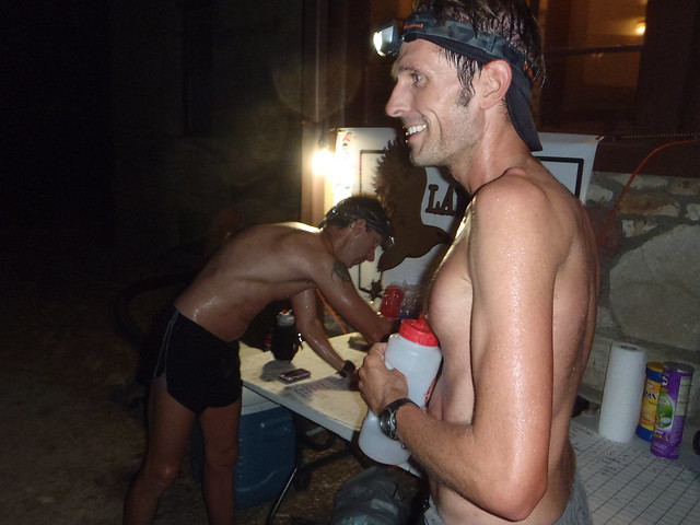
Instead, courtesy of the fun and welcoming Coleen Voeks and the Lawrence Trail Hawks, a Friday night run was going on just a few miles from where we were staying in Olathe, KS. This meant I could meet some new people, and get a trail run in without missing anything else. And, I would get some quality night-running training in as well!


The run is configured as a 3-mile trail loop. A shorter loop course isn't always the most fun during the day, but has many advantages for a night time run such as this, where one could get used to the rhythm of the trail and not get lost (especially with excellent marking), and aid/water were easily available.

I had vague notions of running anywhere between 30-40 miles, hoping to run between 8pm and 3am, but as it turned out, I didn't start until 9:30PM. Before that, we went to watch Tom's softball game, and they were shorthanded on players, so I played in the first game, intending to head out afterward. But they were still short on the 2nd game, as no extras showed up, so I played that one as well. I didn't really contribute anything offensively, but had a fun time and didn't break any bones (2 of 3 broken bones I've ever had were from playing softball).

So I arrived an hour and a half after the running started, missing the turn initially over the top of a hill on a dark, country road. But off to my left, I saw the magical sight of distant headlamps out in the woods, and knew that I was near. I arrived to find the parking lot full, and the festivities already in full swing. I signed in to a big board with a lap count on it, seeing that dozens of people had already started and some of them had finished, intent with a lap or two. I met Coleen, and then headed out for the first loop.

This was my first test with my Black Diamond Spot headlamp, and other than some initial usability and adjustment issues, I was happy with the comfort and brightness of the light. In fact, after the first mile or so, another runner (Al) and I started chatting and kept pace. His headlamp batteries, so we shared the light from my headlamp, and he told me a bit about the course and the group. Oh, and I asked about poisonous local fauna: he told me about several recent encounters with copperhead snakes, but suggested they "probably" wouldn't be out at night, but they're so hard to see that I might not notice anyway.

As for the course itself, despite evidence that Kansas is indeed flatter than a pancake, this course was very enjoyable and had 4 legitimate hills in it. By "legitimate", I mean you had to be careful of footing and speed on the downhills, and the uphills included a short, calf-kicking steep section near the end, and several slightly longer grunts that require a different gear to get up.
Later, I learned of stats of 2k feet gain for a 30M loop -- not incredibly hilly, but a nice mix. The entire loop was very runnable, and included some sections out in the open prairie, before dipping into the forest and along murky ponds with a chorus of bullfrogs and cicadas. And for being a 3 mile loop, people actually get strung out pretty easily, so I would often go a mile or 2 before seeing another person (usually 2 or 3) running together. We all had brief greetings, and I had a few chats around the aid station, but mostly ran an even pace by myself, enjoying the evening.

Although I enjoyed the course, I had surprising problems with the heat. Not surprising in terms of preparation, as I was refilling twice as much ice water, twice as often, as I would have done in a daytime Colorado run in full sun, and I've been doing a decent amount of running during the heat of the day lately. But the nighttime humidity ended up being more of a psychological surprise. By the 3rd lap, I consciously started thinking about the heat, and just after midnight, something switched inside of me where I started getting angry at it. The heat and humidity, that is. I had been running for a couple hours, into the middle of the night, but improbably, it actually got hotter. (I say "improbably" only because my brain expects that, when it's dark out, it gets predictably cooler outside). I did drink plenty of water (on the order of twice as much as a usual daytime run around here), and consumed sufficient salt, but I had this feeling of oppressive wetness -- I would sweat, and dump water over my head, but it was just stick to me and go nowhere! I saw tiny droplets in my headlamp, especially when I breathed out -- with a dew point in the mid 70s (it rose after the sun set!), you could literally see the humidity in the air. And the clouds: there wasn't a star in the sky, despite long views to the horizon. The clouds were trapping us in a greenhouse, and minutes and hours ticked by without any relief. Now I grew up in Wisconsin, and have certainly been in and run in tropical places, but something about running longer at night, in these conditions, set off a strange disconnect between my expectations and reality. Running, and training, has such a rhythm and predictability to it, of knowing your surroundings as well as your body, but here things were not obeying the simple physical rules I expected! I don't whine about the weather at home, as I look forward to the first snow runs, slush runs, and cold rainy runts, as well as the typical hot but dry days. I ran the Twin Cities marathon in 2007, which was actually hotter in the first few hours than the infamous Chicago marathon, and still enjoyed it. But when it comes to humidity, I have to take a moment to tip my salty visor to the folks that have been dealing with it for months this summer.

So I accepted the humidity, and kept ticking off the laps, squelching thoughts of thinking about how many more miles/hours I intended to run -- good practice for the longer runs -- and hit a low/tired point in the 20s but keeping a generally steady pace. I ran a lap with Rick, who finished out at 50k and had run Leadville a couple times, told me about his experiences there. I had been planning on 30-40M, and eventually settled with 6 hours total time. This put me on pace for 36M with stops. I spread out a mt. dew and a Red Bull over a few laps, and I started feeling better again, so my last 2 laps ended up being faster and enjoyable. I finished the last lap feeling like I could keep going, so I know I got what I wanted out of the training.

Overall, a great group and a great trail run out in Kansas! This will be a great memory for Leadville and the rest of my life, and I look forward to more meetings with Lawrence-area runners in the future!

*
That wraps up the final 2 long weekends: a 38M-20M block and a 20M-36M block. Nothing at elevation, but all runs were either mid-day 90+ on the trail or nighttime running, which has to count for something.

Monday, July 25, 2011

Finca Organica de Oscar

I'm looking for Iron, and by happy coincidence, our friends Oscar and Paige have an abundance of kale.
A native of Nicaragua, Oscar is nearing his completion of a degree at CSU, and has a plot of land in North Fort Collins where he is successfully growing a variety of vegetables organically. They graciously invited us over to pick some vegetables and see the farm. He has experimented with some natural ways of increasing nitrogen and decreasing salinity of the soil, and protecting some of the leafy vegetables with natural pesticides. We can barely grow anything in pots on our balcony!

But I think the whole place is actually run by their adorable and precocious bilingual 3-year old son, Tait, who showed us all the different vegetables, shared all of them, and happily eats freshly picked carrots:

Carter Lake Ride


Nora, Deirdre, and J at Carter Lake


With their century ride coming up, J, Nora, and Deirdre were looking for a challenging training ride, and it's hard to beat the classic Masonville-Carter Lake Loop. This loop begins with great climbs past Horsetooth, a tougher climb to Carter Lake, and some rural cruising in between, but has sufficient shoulders and driver awareness to make it safer and less intimidating than some of the canyons. I've enjoyed this loop very much in the past, but hadn't ridden it this year, and was very pleased to be able to ride it with my wife and friends.

We met early at Spring Canyon Park, which makes for a 50 mile loop. By riding from our house, we would go above 60. After having ridden the dams the previous week, the girls were ready for the first climb, and soon settled into a steady grind up the hill. We regrouped after the first few climbs, and then on the first fast descent, I was happily surprised to see Deirdre come flying by, eventually catching up with another pack of riders! She's an aggressive and confident descender, so I lazily and unapologetically drafted behind her on the next downhill.

Finally we hit the Masonville turn, which was a new and enjoyable route for some of them. The girls mostly chatted, and I was happy enough to ride out for any support, but as it turns out we pretty much rotated so I had a chance to talk with them as well. Soon enough, it was starting to get warm out, we were already at 30 miles, and the Carter climb was in sight.

They weren't too happy with the sight of the climb, which I had warned them about, but (with one quick break) it took 13 or 14 minutes. Then we hit the best part of the ride: as soon as you crest the hill, the reservoir comes into view, the temperature drops noticeably, and the smell of pine trees is in the air. I don't think any of them had been to Carter Lake before, but it wouldn't have been nearly the same experience when driving there. We filled up on water and took some pictures around the lake, enjoying a slightly cooler breeze, before blasting downhill.

We wound our way back through country rodes, and Nora and I worked on some pacing again. Since a headwind picked up just a bit, this made a noticeable difference, but we'd end up pulling away from the others. We headed up Taft, making great time with no mechanicals, and finally hit the last few hills (which always seem bigger) after Coyote Ridge.

We hit Spring Canyon again with 56 on J's odometer -- a great ride! We ran a few errands by bike and then got some well-deserved Wahoo's for lunch. 62M/100k when we got back to our condo, J's farthest ride ever. The girls are looking great for the century ride, one more longer ride and they'll be set for sure!

Wednesday, July 20, 2011

Personal Physiology Results

Earlier this week, I obtained some personal physiology results: basic blood tests and a DEXA body composition scan.

I have these results by stroke of fortune and opportunity: not because I have an excess of money and an obsession to move higher in the ectomorphic pantheon of unpaid ultramarathon running; rather I was paid for these results as part of an ongoing research study (more on that when I can discuss more about it).

These test were at the University of Colorado Hospital in Denver, where I am fortunate to be employed in a research fellowship. Lately I have had more time to wander the hallways of the hospital, both as part of my own budding research as well as this study, and I am even more impressed with the highly-talented and motivated staff who are both enthusiastic and willing to discuss research and share data with me. Along those lines, I am making these raw data public for anyone else that might be interested, as I am a physiologic data geek.

*

Personal observations:
- My blood pressure (not shown) is, again, prehypertensive (13x/9x). I will again monitor this, as it has been slightly high in the past. Exercise is known to reduce blood pressure, but a physician yesterday told me that this effect lasts only up to 18 hours, which could have affected my results. This may well also be an inherited salt-sensitivy. I cook most of my own food and use salt sparingly, having to intercept fresh food before liberal salt is dumped on by my wife and others, but I can be more diligent about that. I love bananas already, but can investigate how to add more potassium to my diet.
And as much as it pains me to say it -- I may have to rethink cheese.
- BMI of 19.8
- Body comp through DEXA shows 9.8% body fat, about 1% higher than the last time I had it measured with calipers (for free at work, and I was probably the same BMI). DEXA is more accurate. Interesting assymetries which I'm curious to learn more about.
- Hemoglobin is on the low end. This can happen during intense training. I try to be mindful of my Iron intake since I don't eat red meat, but I can easily add more spinach and kale.
- I can gain or lose weight and still be perfectly healthy, but I'm comfortable at this weight (have been for 3-4 years) and feel healthy (get sick 0-1 times per year, never get headaches or have to take any sort of drugs). Awkwardly, a few acquaintances make weird comments occasionally about (me) being skinny, although I think very little about my own weight, much less theirs.
- Very happy with my cholesterol: HDL is nearly equal to my LDL, which seems to be an off-the-charts ratio. In 9th grade, I was diagnosed with high cholesterol!

Personal Physiology: DEXA Body Composition Scan

Personal Physiology: Metabolic, CBC, and Lipid Test


ComponentMeasurementNormal RangeUnit
WHITE BLOOD CELL COUNT4.44.0 - 11.110
RED BLOOD CELL COUNT4.744.76 - 6.0910
Hemoglobin14.214.3 - 18.1g/dL
HEMATOCRIT42.639.2 - 50.2%
MEAN CORPUSCULAR VOLUME89.980.0 - 100.0fL
MEAN CORPUSCULAR HGB3027.5 - 35.1pg
MEAN CORPUSCULAR HGB CONCENTRN33.332.0 - 36.0g/dL
PLATELET COUNT195150 - 40010
MEAN PLATELET VOLUME11.59.6 - 12.8fL
RED CELL DISTRIBUTION WIDTH SD44.537.1 - 48.8fL
RED CELL DISTRIBUTION WIDTH CV13.511.7 - 14.2%
NRBC PERCENT00.0 - 0.0%
NRBC ABSOLUTE00.00 - 0.0010
CHOLESTEROL1450 - 200mg/dL
HIGH DENSITY LIPOPROTEIN CHOL6440 - 60mg/dL
Non HDL Cholesterol810 - 160mg/dL
TRIGLYCERIDES710 - 150mg/dL
LOW DENSITY LIPOPROTEIN CHOL670 - 130mg/dL
SODIUM,SERUM/PLASMA140133 - 145mmol/L
POTASSIUM, SERUM/PLASMA4.33.3 - 5.0mmol/L
CHLORIDE, SERUM/PLASMA106101 - 111mmol/L
BLOOD UREA NITROGEN1540717mg/dL
CREATININE, SERUM/PLASMA0.90.40 - 1.20mg/dL
GLUCOSE, RANDOM, SERUM/PLASMA9170 - 199mg/dL
CALCIUM, SERUM/PLASMA8.98.5 - 10.3mg/dL
ASPARTATE AMINOTRANSFERASE300 - 47U/L
ALK PHOS, SERUM/PLASMA5539 - 117U/L
PROTEIN TOTAL, SERUM/PLASMA6.26.4 - 8.3g/dL
BILIRUBIN TOTAL0.60.0 - 1.3mg/dL
CARBON DIOXIDE2622 - 32mmol/L
ALANINE AMINOTRANSFERASE220 - 47U/L
ALBUMIN3.93.4 - 5.0g/dL

Sunday, July 17, 2011

Half-Baked Triathlon

1/2 century, 1/2 mile swim, 1/2 marathon

Bike

Rode 50 in the AM with J and Nora, who are training well for their 1st century:
Today was a flat ride for the girls to get the miles in. I forgot how beautiful the country roads on the plains can be in the morning:


I couldn't help but make amusing (to me) gender comparisons. The girls chatted for miles, often remarking about big, beautiful country houses in the rural parts of Weld County. I thought about Nick and I, just yesterday, spending our time identifying all the surrounding peaks from the summit. I guess it's kind of the same thing? Anyway, I think the early miles went by quickly as the girls were talking.

We road Kechter out before dropping down to 392 to Windsor, then wound our way back, ultimately ending up on a section of the road that becomes Horsetooth in Fort Collins. Again, as I haven't ridden like I did a few years ago, things were new, and it turns out that stretch of road was newly, and gloriously, paved and uncrowded.


But I was also hoping for some training on the ride. I started it out early by showing (again) how to fix a flat -- mine. Got J to spend more time in her big ring and push more, rather than spin. After looping through Weld County, then, we hit the Frontage roads. Not great scenery, but not too crowded and easy to get a rhythm.

I didn't push a paceline too much, but suggested J ride behind Nora and try to match her speed. Sure enough, she nudged closer and they hooked up pretty well. Nora took some great pulls and I eased in front slowly to show her the difference that drafting makes, and then pointed out some etiquette about consistent pace, soft-pedaling, and using the shadows on the corner of the eye to make sure you don't drop the line behind you. The girls then held steady and kept up a solid stretch of ~17-18mph on the flats -- I was so proud! The key seems to have been finding a long enough stretch for a consistent pace, and not starting out immediately in the ride when they were in more of a rhythmic mood.

We headed up to Wellington before looping back down. Our fortune in new pavement was taken away on a soft surface with crappy regrading down from Wellington, all the way past the Waverly turnoff, but soon enough we were down to Lemay and enjoyed back into town, hitting 50 right at Rocky Mountain Bagel Works. Having started early, we had beaten the heat, and it was still breakfast time with plenty of daytime left!

Great ride with the girls, really proud of their work and attitude today, fun ride!


Swim

We decided to cool off in the pool, and J and I started some laps, then as they were chatting again, I snuck in more laps, eventually hitting a 1/2 mile. This isn't easy for my crappy swimming style, in which I have to stop every 1-3 laps to catch my breath. Still, I figure it's good for the darkest parts of an ultra: it's boring, tedious, pointless, I'm moving slower than a normal person can walk and I hate it, yet I still can't breathe and my heart's beating fast.


Run
Slow 1/2 marathon loop around the hood.

Anyway, not the normal grind-it-out ultra miles that I'd normally plan on, but something different and more fun to keep it fresh. Somewhere around mile 60-70 in Pbville, I can think to myself: "It could be worse. I could be swimming."

Mt. Dunraven and Mt. Dickinson Loop from Dunraven TH


Mt. Dunraven (12571')
Mt. Dickinson (11831')
~21M from Dunraven TH, ~1M elevation gain
7 hours RT with Nick

After a remarkable fortnight in which he placed 3rd (and remarkably high in all-time finishing times) in both Western States and the Hardrock 100, Sir Nick was back in town and looking for a decent run. I suggested a hastily-researched loop which included Mt. Dunraven and Mt. Dickinson, two less popular peaks on the border of the Comanche Wilderness and RMNP. His writeup is detailed enough for anyone else looking at this loop, so it's now the pre-eminent source of some peaks that didn't have much information about them.

The route begins with a run along the North Fork of the Big Thompson river, up to Lost Lake, which has some great recent beta from Rob. This is a popular backpacking area, on a trail which also leads towards Stormy Peaks, another great run. However, I've been drawn to the obvious rolling tundra above this trail, forming the ridges of Mt. Dunraven and Mt. Dickinson. Lisa Foster's excellent RMNP hiking book has some mention of these peaks, noting the more obvious Class 2 approach above Lost Lake. Also intriguing, however, was the Northeast Slope route to Mt. Dickinson, which would make a lollipop route possible back down to the Happily Lost campground, just over halfway up the trail. This sounded promising enough to scout out, and with a clear view from the top we had a hopeful possibility that we might be able to head due East to the North Boundary Trail. That was not to be so, and although the mention of the route description was comforting in that there were no terrain traps by dropping back down to the North Fork, the phrase "bushwhack" being used twice did end up making this section of the 'hike' a slog.

As it turned out, we had a great run up to Lost Lake in just under 1:50, and then switched into off-route mode with some snowfield and creek crossings. The creeks were still fast enough -- it's July! -- to warrant a bit of investigation, but ended up being entirely manageable. Next up was a constant march up to Dunraven, a steady grunt up talus and tundra, all the while enjoying the above-treeline views.


A summit register on top was dated from 2006, and had only 3-4 pages of signatures -- a far cry from anything on a 14er! We identified the surrounding peaks, either by map, or familiarity from previous excursions or planned future ones, before heading down along the ridge to Dickinson. This was a straightforward hike across the familiar tufted, uneven tundra that marks the Mummy Range -- easy to manage but watch your ankles. We skirted around the lesser "Dunraven Knob" before heading to the Dunraven-Dickinson saddle, and enjoyed Dickinson's more prominent peak. Again, a summit register was present, but had much fewer visits than Dunraven. One of the entries mentioned bushwhacking up from the Happily Lost campground, so we were hopeful about that possible route. Since backpackers often stay there, some summit attempts would naturally include day trips from the camgpound.

With that, it was time to scout the return trip.


Trees, trees everywhere. It didn't look that far, so down we went.
We hoped we'd find some evidence of usage, enough clearing in the trees, some game trails, or something, but instead we got more snowfields, deadfall with pointy limbs, and thicker trees. The slope was manageable, but we essentially slogged straight down the hill for an hour and a half or so. Nick remarked it would have all been worth it if we at least saw a moose or an elk, but no such luck (plenty of evidence, however).

Finally, the roar of the North Fork grew louder. Crossing there was as good (or bad) as anywhere else. And where did we hit the trail? Nearly dead-on with the Happily Lost campground! Although we didn't see any evidence of trail use, it was pretty cool that dead reckoning and lack of visual cues still worked out as planned.

Now we had 6 miles to run back, which was just an anxious cruise down the trail. For being tired and beat-up, it's still fun to watch Nick run down the trail, and at least have a hope of hanging on.

All in all, a solid day with some new peaks. Hard to call this loop a 'classic', but nice to get up there, on what was essentially 3 hours of running, 2 hours of stairmaster, and another 1.5 hours of stepping over trees. Is that good training for Barkley? (Answer: No, because that's ridiculous).

Saturday, July 16, 2011

Rox-Brewers

Brewers lose away (again), fall out of first place, Braun's hitting streak ends.

Otherwise, a nice night at Coors Field!


*

On the way home, we spotted a driver weaving obviously into the next lane, then quickly correcting. It wasn't into other cars or anything, but they guy kept doing it. As I was driving, I pointed it out to Caleb, and he agreed it was pretty obvious. By then it had been for 3-4 miles, and Caleb called in *CSP. I've done this a few times and nothing interesting happened, but this time...CSP called him back! Turns out they had a trooper 3 miles down the road. They asked us to update them on the position, trail the car safely, and put on my flashers -- wow! They got behind him, and the guy indeed swerved 2 more times, and they (two squad cars now) pulled the driver over.

They asked us to stay put and wait (somewhat unexpected for us). They came back after checking the guy out. They said he was sober, but really tired from driving from the Springs and had a small child in the back of the car. They were inclined to give him a warning, unless we wanted to show up in court to testify what we saw (no thanks). But they were still cool and grateful and encouraging of calling in.

Somewhat disappointed that it wasn't a real DUI, but I'm guessing the shot of adrenaline from getting over was helpful for this driver. But also disappointed at how much we tolerate crappy, dangerous, distracted driving in this country. We talk in this limited Blogosphere about the dangers of mountains, weather, etc. but really it's some tool in another car on the drive home that's the biggest realistic threat.

Anyway, an interesting process to observe nonetheless.

Thursday, July 14, 2011

Book Mini-Review: "Unbroken"


I listened to the Audible audibook version

Laura Hillenbrand's "Unbroken" is a phenomenal historical account of the life of Louis Zamperini, and is certainly topical to those interested in both running and survival history, in addition to a deep account of the Pacific theater of WWII. Zamperini was a world-class Olympic distance runner who was honing his skills in the mile when war interrupted his promising young life. As a bombardier in bulky and unreliable aircraft, he had numerous close calls. Eventually, instead of having a chance to battle for the coveted 4-minute mile, he instead was focused on unwittingly attempting to surpass the world record for survival at sea, and eventually survival as a prisoner-of-war. And these are only the basics of the story, I'm not really giving away anything here, as the details are more incredible.

Finally, the biggest realization I had from this book was letting the details of the war settle in for several hours, from the point of view of a single actor, and then imagining the psychological impact of the atomic bomb, from the point of view of a world that had little to no previous understanding of it. I've read technical accounts of the Manhattan project, and reserving any judgment on the overall merits of the bomb, I've never properly imagined the disbelief of soldiers, civilians, and especially prisoners at the moment a devastating yet decisive force was unleashed in the world.

But back to the individual level, the story of Zamperini is absolutely incredible, and highly recommended.

Wednesday, July 13, 2011

Racing with my Godson

Last month, my cousins were kind enough to have a picnic where we were able to visit with the family in Wisconsin. My godson Max, who just finished 2nd in a x-country race at school (and also plays baseball, soccer, swimming, and races bikes), and I had a fun race around the block near his house.


The first lap was running, and he ran the entire loop (almost a quarter of a mile!), awesome! He used some strategy to try to fake me out, saving a good kick for the end of the run. The finish was too close to call!

Next, he raced on the bike. His parents had said that maybe we should go sometime where I ran and he rode his bike, and he said, "But that wouldn't be fair!" -- what good sportsmanship! Again, he saved some bursts of speed for the end, and we finished at the same time. He told me he was pretty tired afterward, but was full of energy approximately 10 minutes later. Meanwhile, I was drenched in sweat!

It sure is fun to see him, his brother, and cousins all getting older and into different activities. I had a great time running with Max, and can't wait to do it again...I know he's going to keep getting faster though, can't wait to see that!

Sunday, July 10, 2011

More Running in the Sangres: Humboldt Peak


Humboldt Peak (14064')
Standard Route from lower 2WD TH
18M RT, 1M elevation gain
~5:10 moving, 5:45 total

I wanted to maximize my time with a quick weekend in the Sangre de Cristo Range, so I checked out Humboldt Peak. Among 14ers, Humboldt is deserving of its reputation of being comparatively easy, especially among the Sangres, when approached from the Class 2 walkup standard route from Colony Lakes. However, this "shapeless hump", as Roach calls it, also provides a great vantage point for viewing the Crestones, shown here in morning alpenglow:


The Colony Lakes area below is a common approach to Humboldt and surrounding peaks, and is therefore a popular backpacking spot. In the last couple years, several miles of very rough road have been gated off, to the dismay of the drive-slower-than-I-could-walk-or-bike crowd. The lower part of the road is still open and more manageable when going slowly, but in order to make this route interesting, I started at the very bottom trailhead. I am (still) not collecting 14ers, but this sounded like a good addition to a decent run.

I set up camp Saturday afternoon at the trailhead, where a few cars were parked and another showed up shortly after, with Sal(?) and his son Mario and dog Jake. We chatted a bit that night and the next day, it turns out 8-year-old Mario is into climbing the 14ers and has done quite a few already, eager to do more. The best part was when he said to his Dad, "Well I think I'm going to start getting ready for bed so we can get up early tomorrow!" It was cool to see his enthusiasm. They were setting up a camper and planning on driving up to the upper TH in the morning.

My 'camp' was sleeping in the back of our Civic -- did I mention we bought that for gas mileage (~40mpg for my Denver commutes) and that part of my test drive was folding the seats down to see if I could fit? Anyway, I do and it works nicely.

I wanted to get up around 3 for an attempted sunrise hike, but awoke to some light rain. I thought about it some more and then heard thunder, which settled it for me. I waited a bit, and by 4:30 the rain and thunder had both passed. That also meant more sleep and less time jogging at night during prime mountain lion time. So by 5AM, I was off, and only needed the headlamp for less than half an hour.

The road was a nice start to the run because it's easy and straightforward even at night. I had thought that I might be passed by cars heading up on the road, but instead my run was blissfully quiet and calm. Eventually I hit Colony Lakes, where I saw 2 people heading down from dawn patrol. Seeing them bundled up, I then remembered that sunrise hikes are always more romanticized than reality: usually the wind picks up right as the sun is rising, and none of the peak is yet exposed to the warmth of the sun, so you might be sacrificing 10-20 degrees of temperature right there.

After the road ends, the trail narrows and undulates before finally reaching switchbacks at timberline. Were the switchbacks runnable? This guy says yes:


Unfortunately, I tired out a bit and hiked most of this, so I wasn't making any blazingly fast progress. Mostly, the incessant wind made it even harder to breathe. But I caught up and passed the only other 2 guys above treeline. Rather than being busy with peak-baggers as I feared, the early morning was serene and I only saw 4 hikers on the way up. Finally, the views (and wind!) opened up at the top of the ridge, which is all Class 2. Some faint trails and cairns wind here-and-there, but awkward steps, wobbly talus, and directional changes mean that the running is over up here, and it was also time to put on pants (legs), wool hat, and wind shell. Most of the work, then, is up to a false summit, and then a quick bolt up the ridge itself to the summit.

I enjoyed the complete break from the wind and thawed my hands in the sun, with the summit to myself for about 15 minutes, before heading down. On the switchbacks, I saw the trio from the night before, and Mario was still in good spirits, ready to get up top.

After that came more folks in bunches, but still not the huge crowds that I feared.
agoracrophobia (noun): An irrational fear of crowds in high places. Also see: a psychiatrist! (rimshot)

Finally, a long but enjoyable descent on South Colony Road. I took it easy until the last 3 miles below the upper trailhead, and then had fun opening it up a bit. The cursed, rocky road -- no fun for walking or driving -- can be fun for running, with the right attitude.

All in all, another fun route for running, plus an easy scramble up top. I'm just feeling like exploring now when I can on the weekends, which is what summer is best for, I guess. I feel like I'm going pretty slowly, which is the bad news, but I feel like I can keep going slowly all day and night, which is hopefully good news.

Saturday, July 9, 2011

Comanche and Venable: Sangres Loop

~15-16M (an extra couple miles on the Rainbow Trail)
~1M elevation gain
Comanche Peak (Sangres): 13277'
Venable Peak: 13334'
4 hours moving, ~5 hours total

With the monsoon weather moving in, it seemed like a good time to check out the Sangres; which, sadly, are under drought conditions and fire restrictions.

I've had my eye on the Comanche-Venable loop, which seemed like a nice exploration of 2 of the gorgeous drainages to the west of Westcliffe, CO. The loop supposedly had a decent trail, with two sets of alpine lakes, amazing views, and a chance to scramble up the namesake 13ers.

Most intriguing to me, however, was a section of trail dubbed the "Phantom Terrace", which is a singletrack carved into the side of Venable:


This section is clearly a no-go when snow, moisture, or weather are present. Fortunately, the trail was manageable and exhilirating. But I was also glad to be done with it!

Here's a short video:


The rest of the run/hike was spectacular as well: very green and full of wildflowers.


The scramble up Venable was steep grassy tundra with some rock obstacles to slow you down, and Venable is less impressive from the backside climb -- just a ho-hum endeavor. Comanche, on the other hand, is a fun charge straight up the ridge (form right to left, shown behind me):


The lakes themselves are a righteous destination as well, especially for fisherman. The Venable trail was rockier than the Comanche trail, and ultimately the descent below Comanche lake on the trail was straightforward and fun.

All in all, a beautiful area. Check out the map: there's a trail heading up each drainage (at least 10 different ones) to some impressive peaks from the East, and notable descents on the west side as well. With more route planning and familiarity with the terrain, some huge combined loops could be made.

Hardrock Congrats

Same thing everyone else is saying, but awesome job from Fort Collins runners Dakota (2), Nick (3), and Pete (15)!

Sunday, July 3, 2011

Pikes Peak or Bust


Pikes Peak Marathon Route (Barr Trail/Cutoff from Manitou)
26+M, 7800' gain
6 hours moving, 7 hours with gaping and donuts


I decided to go up Pikes Peak on foot for Independence Day weekend. This wasn't necessarily spurred by my patriotism and the desire to go up the peak that inspired "America, the Beautiful," but mostly laziness on planning a route for a decent long run and wanting to go up a peak without snow or routefinding issues (that also has donuts and coffee on top). Plus, though I knew it would be relatively crowded, that made it easier for me to be lackadaisical about overpreparing for safety considerations. Especially since I decided to do this at about midnight before going to bed, only to wake up at 4AM to drive down there on Sunday. (I wish I had planned better, I certainly could have carpooled with some folks from the Fort. When you ride alone, you ride with bin Laden).

The Barr trail is a Class 1 trail that winds its way up from Manitou Springs, below 7000 feet, to the top of Pikes, which is above 14,000 feet. This is the most gain of a single trail in the state of Colorado. For this reason, it's the site of the annual Pikes Peak Ascent and Marathon in August of every year (the same weekend as Leadville). I've never done it, but certainly appreciate the vast amount of information online about the course. Some people are really into this race. I didn't initially "get" this, as my only previous visit, driving, made me feel like it was an uninspirational tourist trap, but after spending the day on the trail, I only just began to understand the appeal: the varied terrain and character of the race make it a very tactical one, and I can only imagine that charging back down into Manitou with crowds at the finish line would be quite memorable.

But this was just a training run, and I had no idea what to expect. I do recall reading that a common estimate of the ascent is roughly your flat marathon time (if you're used to some altitude), so I figured 3-ish hours on the ascent. Mostly, since I left at 7am, I wanted a realistic buffer for getting up and back down to treeline before possible afternoon storms. But that would be a consistent race effort without taking any wrong turns, and since I characteristically failed at that, I ended up taking almost 3.5 hours up. First, I ended up taking a wrong turn somehow and ending up near the top of the Incline. On the correct return route, I traced my wrong turn to a small trail between the National Forest sign and the Rock Arch. Whoops! I'm guessing I followed somebody nearby on that turn or saw people above and headed that way, it sure got steep in a hurry. I had to ask a few people how to get back the Barr trail and only one guy out of a dozen or so had an idea, which led me back on track.

Shortly after that, back on track, I felt something hit against my leg. I checked my pack and found it was still closed, thinking that my pockets were otherwise secure, so I kept on. Luckily, I noted the spot that that happened, because 5 minutes later my keys fell out of my back pocket (mt. bike shorts with a hole in them). That meant that the previous item was my cell phone, which was also in my back pocket, 5 minutes back up the trail. I headed back and looked for a good 6 or 7 minutes, before luckily spotting the phone off the side of the trail. Glad I found it, and perhaps with better preparation in the morning I wouldn't have done silly things like this.

Now I was back on track for a grind. I certainly enjoyed the cooler, shaded areas on a day when the cities below were pushing 100 degrees. Trail traffic was heavy for what I'm used to, but definitely respectful and easy to get around people. All kinds of shapes and sizes were out for hiking, backpacking, and running. The running group certainly filtered out after the top of the Incline, and even moreso after Barr camp.

Barr camp had a fair number of people milling around, but I kept on moving. I knew I could get water here if necessary, but I way overdid it and brought 4 bottles with me. I switched out for the other 2 bottles here and the lighter weight in my pack was noticeably appreciated.

Now more of a grind up, and I was definitely appreciating the above-treeline views. It now looked like a legitimate mountain. The weather was gorgeous, with a very light wind that was manageable with shorts and a long-sleeve shirt. Again, in the theme of overpreparation, I had a solid windproof/waterproof shell that I ended up not needing at all.

Despite some sections being steeper than others, I prided myself on running every step, save for a few 2-3 step sections through tight boulders. Finally I hit the (in)famous 16 Golden Stairs, which were rockier, and I didn't mind hiking here with short occasionally running spurts. Finally, I hit the summit right around 4 hours on my watch (including the backtracking and cell phone search) -- the most surreal summit situation I've ever been on.

Inexplicably, however, despite having a routine run on a mountain route I wasn't particulary focused on, I was hit with a massive wave of a runner's high at the top. This hasn't happened quite as dramatically in a year or two, and I can't quite predict when it will, although my unscientific observation is that it generally occurs when relaxing after a very long but steady effort (I've had the feeling more frequently on long, multiple-mountain pass bike rides). I can't predict nor understand this stuff. I was quite at peace and relaxed on the way up, and said hello to every single hiking group I encountered (which was dozens). The entire run, I was quite happy and at peace with the surroundings. But then, after all that work, you're treated to a parking lot full of tourist gapers, huffing and puffing at the prospect of getting from their car to the gift shop.

So, my runner's high was short-lived as I re-acclimated into the mundane. I had to cut through gift shop lines just to get to the cafeteria area. I waited in line for summit donuts and a capuccino. In a thick southern accent: "Daddy got a dozen donuts, so 2 for each of you" as the kids whined impatiently. Despite perfect weather outside, the tables inside were packed with people eating, consuming crappy food and crappy gift-shop trinkets. Why experience something when you can buy it? The American Way. At the time, though, I was just an amused and calm observer.

I didn't feel like waiting in line to take a picture in front of the summit sign, so I walked over to a non-descript pile of rocks forming the true summit. I was alone, briefly, before a few others wandered over and thanked me for showing them the "real" summit. I snapped a few pictures for them before heading off.

Now despite my superior mountain attitude evident in the previous few paragraphs, I finally looked up at the sky after 25 minutes of dawdling, only to notice a dark cloud enveloping the entire summit. Rookie! Time to head down, quickly! Right at the top of the trail, a family posed for a picture for Dad above, without room to sneak behind. (Never stop in the middle of the trail/Be sure of what's around you). Call me a jerk if you want: I'm not sure if I was too impatient to wait 3 seconds or if it would have been 20, but I kept running, and the guy sarcastically said, "Thanks." In stride, I replied, "I have to run 13 more miles to avoid a storm, I'm not concerned about your *@#$ picture!" I hope that picture was a keeper.

Within minutes, it started precipitating. Guesses? Snow! Snow, on the 3rd of July. Enjoyable for the time, though, as the wind wasn't picking up, and there was no lightning or thunder. On the way down, as the snow stopped, a few people asked for weather reports. One group thought about turning around, and though I'm very conservative about lightning, I told them I couldn't strongly recommend not going for the summit, which might even be safer/closer for them. As it turned out, a few large clouds came over the summit, and all of them swept nicely to the Southeast, leaving most of the trail safe from weather.

I took it easy coming down and it was probably relatively slower (compared to race day) here than going up. Nearly everyone yielded but I didn't expect it, as I generally yield to uphill folks if possible. Happy to make it back down to treeline but still no real storms to speak of. Then, just kept plugging away down to Barr, and traffic was light and sometimes non-existent for longer stretches of time.

Finally got back down to the split toward the Incline and made note of my wrong turn. I knew I was within 40 minutes or so of my car and still had 2 water bottles left, so I switched out for the final time. Just before I started running again, 2 guys flew by. They were going slightly faster as I started running again, and they had bright white shoes and cotton sports shirts on, military muscle, and music loud enough to hear as they passed. I hadn't been passed all day, and my pride made me want to go a bit faster, but I told myself they had been doing a much shorter run and this was foolish. I kept my own pace while thinking about it, and as they hit the next switchback I heard sliding gravel, a thud, and curses.

One dude was face down in the dirt, his friend waiting by him (earbuds still in on both of them). We both asked the guy on the ground if he was OK, no response. I said, "Let's give him a minute, it probably hurts like hell and he's trying not to pass out or puke." After awhile, he sat up and did a systems check. His leg was scraped, but his friend checked out his ankle. "Oh, dude!" He could feel the ankle, but it was already visible swollen, an extra golf ball that appeared in minutes. He explained how he "Just did that last week but it was feeling better" and that they were feeling good coming off the Incline so he wanted to push it. I offered him water and he accepted, then his friend asked for some since they ran out. No problem, that's why I had extra. I said I'd stick around to see if he needed 2 people to help him down. He eventually got up and slowly hobbled under his own power, so it seemed like his buddy would have been sufficient if he needed it. I told him to find a stick (I didn't see one immediately) to keep weight off of it, but there wasn't much more to do (and plenty of other traffic), so I headed down.

Finally, back down to the creek, then the merciless pavement (Ow-Ow-Ow) and then Manitou itself. It was so quiet and quaint in the morning, and now it was lousy with tourists! I dodged parked cars, Harley's, and cigarette smoke, eventually getting back to the car in the park by the civic center, 7 hours after I started.

I enjoyed the simple route and logistics, and although I can't stand the summit parking lot and the sad way we generally relate to nature (at least I had low expectations: the crowded valley floor of Yosemite was more disappointing to me because I wasn't expecting it), the Barr trail itself is actually decent. This was slower than I might have liked, but I won't read too much into it with the extra gear I was carrying. All in all, a fun training day with some elevation.

Leadville Love


Update This.

Mt. Massive South Slopes

Update This.

Lapham Peak, Wisconsin

Update This

Wisconsin Cuisine

Cheese curds in Tomah, Wisconsin:

...but you can find places for cheese off the interstate away from the city, especially. J and I call every cheese place a "cheese castle" in honor of the Mars Cheese Castle in Kenosha. Brand name dilution, kind of like "Band-Aid" or "Kleenex"

Here's a 2-liter boot (only $15 on Thursday's!) at the Capital Tap Haus in Madison:

Capital makes some good stuff, and this is a much better location than going out to Middleton (suburb of Madison). The patio is just a block or two from the capitol, giving a prime seat for viewing the governmental dismantling of the state.


Checked out The Grumpy Troll in Mt. Horeb, Wisconsin:


This pretzel is a pound and a half.
Fun place, good selection of food and beer. In the hilly rural areas southwest of Madison, great bike riding territory. They just came out with some sweet bike jerseys. The beer is above average and is either all unfiltered or relatively unconcerned about colour or clarity, but gets the job done.

Finally, went out to check out Wisconsin's best microbrewery -- New Glarus -- in another quaint rural town, of Swiss heritage, outside of Madison. Been wanting to go there for years, and found out that they closed at 4pm on weekdays. We got there at 4:02. I was able to quickly get a few souvenirs and some bottles to bring back, but was disappointed not to get any tastings. However, the tastings are reasonable but not free, and they handed out coupon books for a free 10oz tasting at one of several local bars. That ended up working out better, as we checked out Glarner Stube, a Swiss bar/restaurant in town. The only beer they had on tap was fresh New Glarus.


I never explored any of these areas in 4 years of school in Madison, but never did any distance biking, either. A great tour would involve the hilly backroads of some of these towns -- all the beer and cheese you need.

Dinosaur National Monument

Update this.