Sunday, September 9, 2012

A Circle Tour of the Circle Peaks in RMNP


Peaks shown from Trail Ridge, picture from Summitpost.

Mt. Ida
Chief Cheley
Pt. 12820
Cracktop
Mt. Julian
Terra Tomah Mountain (12718')
~14.5M, 6000' gain, 8 hours

When recently visiting the high point of Trail Ridge Road, our view was drawn to some of the peaks just off of the Continental Divide, especially Mt. Julian (the most visually prominent of the peaks). It was apparent that these peaks can be connected for a nice long ridge run, and internet research suggested that the route would be fairly easy, with a combination of Class 1 runnable trail, much Class 2, and a bit of Class 3, with the bulk of the route above treeline. When we factored in another pleasant weather forecast, Nick, Steph, and I were up for a Rocky Mountain adventure.

Our goal included 6 peaks, and is described as the "Circle Peaks" and "Gorge Lakes Peaks" for the respective cirque formed by the mountains around Gorge Lakes. Our proposed route involved a fairly straightforward ascent of Mt. Ida, followed by a ridge run all the way out to Terra Tomah, followed by backtracking and some possibly different descent options once in the field. All 3 of us had the Trails Illustrated RMNP with us, but we could just has easily brought postage stamps with us instead.
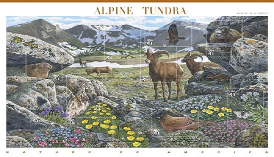

Indeed, these peaks are so visually stunning, they were an inspiration for a USPS "Alpine Tundra" stamp.

By first light, we had crossed the high points of Trail Ridge on Iceberg and Milner Passes, descending to Poudre Lake, where we started our journey.
The first peak was Mt. Ida, a flat summit that slopes gently toward the divide. In that respect, and more, there are similarities between Ida and Flat Top mountain in RMNP, as both have runnable trails over 4 miles each way to the summit. The trail to Ida isn't marked on all maps, but is definitely a pleasure to hike or run.
I am unsure of Ida's naming, although that mountain name is prominent in Greek mythology.

We gained Ida with steady hiking in just over 80 minutes, and now had view towards Chief Cheley Peak, which had a more satisfying and accessible summit. (For anyone considering a hike of Mt. Ida, it's definitely worth it to add on a summit of Chief Cheley).

Pics courtesy of Steph and Nick

In the short approach to Chief Cheley, we had enough time to ponder the naming of the peak. We guessed a Native American heritage, but looks like we missed on that one. Instead, Chief Cheley Peak is named after Frank H. Cheley, who was known for directing a boy's camp in Michigan, Camp Eberhardt, in the 1910's. He authored several books based on these experiences, and in "The Three Rivers Kids", he included himself as a character known as "The Chief." He soon established himself in Colorado by opening the Bear Lake Trail School in 1921, an outdoor school for boys, and then later expanding to inclusion of a girl's camp as well. The Cheley Colorado Camps exist today. I am curious for further explanation and clarification, especially to know if the actual naming of the peak was based on exploration or honorifics, as the founding of the park predates Cheley's founding of the school in 1921.

After Chief Cheley, there's a ridge with a highpoint of 12820', rolling along directly to Cracktop. Both names are obvious, with Cracktop being named by a vertical slit directly at the summit.

The ridge between Cracktop and Julian is the slowest-going because of more technical terrain, but still remains Class 3 with easy routefinding.

Afterward, we headed to the more prominent summit of Julian, our penultimate named summit, to be followed by Terra Tomah. I've since learned the explanations for these mountain names (as well as reaching the same conclusions on Ida and Cheley) from "Best Summit Hikes in Colorado", with Julian being named after civil engineer and surveyor Julian Hayden. It appears he did some exploration around the area, but other information about Mr. Hayden is scant. It is likely that official Larimer County surveyor Abner Sprague named it simply in Julian's honour, but I am unaware if the imposing nearby Hayden Spire is named after Julian or more famous surveyor F.V. Hayden.

Terra Tomah's explanation is a double misnomer, as it appears to be a mondegreen from a Cohuila ghost dance...but the name was intended for the lake instead, and was mistakenly applied to the mountain.
(In any case, it's a fun name to play with: it also anagrams to "A Rat Mother..." whatever that means).


Mt. Terra Tomah (left) and Mt. Julian (right)


Julian went quickly enough, and was the only summit with a register, and soon enough we were exploring Terra Tomah's flat summit (with a few candidate high points).

Now we were ready for a decision: most routes involve backtracking the way we came. Doable, but loops are always more satisfying. We had another option of backtracking about halfway before descending to trails parallel to Trail Ridge. But, as we stood on Terra Tomah (and having seen it earlier), we thought that descending off of it would be a fun way to explore the lower lakes and benches above them, and lead to a satisfying loop. But would a Terra Tomah face descent go?


We could see parts of the route, and we were aware of some towers, but it looked like we could descend safely, both in terms of the terrain we could see, and by having ramps leading in either direction at the points we could not. We gambled, fully prepared to reclimb and count our losses, and although it was slow and loose (with occasional slabs of granite, sometimes helpful and sometimes too smooth and vertical) I'd say it was a fun descent that kept our attention. Although there was occasional backtracking,we fanned out and took slightly different routes down, suggesting that there were options.

Our descent off of Terra Tomah's East Face, roughly in the middle

Looking back gave us a new appreciation for the mountain, for what appeared to be a non-descript flat summit from the ridge ended up having a quite impressive face. Going down this face added legimitacy to this mountain, in this author's opinion. In hindsight, an easier but longer option would have been to drop off the more gentle South slopes. Also, photographs show that the lower reaches of Terra Tomah often hold snow in the area we traversed, but was dry on the August day in a very dry snow year of 2012.

Now our technical difficulties were over, and we needed to regain elevation as we explored the lakes below. We gained the bench between Arrowhead and Love lakes on solid rock, as we approached an outlet cascade. This is indeed the source of the Big Thompson, a powerful river that has carved out the canyon all the way from Estes to Loveland.

At this point, though, 'twas but a trickle and a jump:


After a brief blitz through willows, we had straightforward options of regaining the ridge to complete the loop. It was a breathless, Euro-hiking grunt, we made it back out of the cirque. Except, there was more elevation to gain as we traced back along the ridge to the Ida trail, which added to the grind.

Finally, we were back to the trail, and it was a fun, clean descent back to the car. In all, I think the Circle Tour of the Circle Peaks was a great route, and it was great to enjoy it with fun and capable friends.

Desolation Peaks RMNP


From 2012-August Desolation Peaks Loop


Marmot Pt. (11,909')
West Desolation (12,918')
East Desolation (12,949')

Nick and I decided to check out a peak-bagging loop focused on the Desolation Peaks in RMNP. He has a more detailed writeup, but essentially we started at the Alpine Visitor's Center, shamelessly grabbed Marmot Point (a high 11er) before skirting along the Mummy Range to hit the Desolation Peaks.

The Desolation Peaks are lesser-visited high 12ers, shyly hiding behind the Mummy's, but more jagged and pointy than the rounder neighbours. The 2 peaks are connected by a jagged, talus ridge, with the East peak being slightly higher. Fun, exposed views await those who venture here.

Unfortunately, with the exposure and significant time above treeline, weather can often be a factor. We had a decently typical forecast, and even with developing clouds, we thought the broken, blue skies in the distance would be sufficient to give us time, after a 10AM summit of East Desolation.

Soon enough, Nick felt his hair sticking up -- so that's what the shaggy ultra-mane is all about, it's a lightning detector! -- and as we descended, within seconds we heard a giant crack (more like an explosion) directly above us.

On the face of it, being on a ridge wouldn't be ideal, but it turns out the ridge has a depth of features not found on the rest of the route. Along a vertical granite wall on East Desolation, we scrambled underneath talus, which formed a rather protective and comfortable cave. We waited for 45 minutes and were relatively sheltered from rain and graupel. The close lightning seemed to be an outlier, as most other thunder rumbles were more distant, with no imminent cloud-ground flashes seen.

We killed time by making a video:

Desolation Peaks - Cave during Storm from mike hinterberg on Vimeo.


Other reports talked about exposed, loose talus on the ridge -- we were not looking forward to this, with the newly added factors of nearby storms added to wet rock (with some accumulated graupel). But being scarcely 10 minutes away, and comfortable with "Desolation Cave" as a retreat point, we emerged from the cave to examine the ridge.

Even while wet, the ridge was far more stable and enjoyable than I had read. I found the large talus forming East Desolation to be generally trustworthy and solid, both climbing and downclimbing, with great exposed views. I was motivated to move quickly because of weather, trying to get into a zone of steady climbing, and found that cracks on the climber's right of the peak provided reliable passage.

East Desolation Peak climb from mike hinterberg on Vimeo.


We retreated safely to East Desolation, with rain threatening but no further evidence of storms. Still, we played it safe by descending off of East Desolation towards the Poudre River, into the forest. Now we were relatively sheltered from weather, but spent the next hour in a longer-than-expected bushwhack.

We (meaning Nick) had initial plans of climbing a lame, forested hump of a hill that had sufficient statistics to be a ranked Larimer Peak. My interest piqued a bit when learning that it had a nickname of "Nutcracker Peak," which somehow made it more interesting than "Pt. 10855" -- but with another forested bushwhack ahead of us, we called it a day. Mercifully, the return to Trail Ridge was uneventful in terms of weather, and was more lightly-forested.

Mt. Meeker and Long's from Loft Route


Mt. Meeker (13911')
Longs Peak (14259')
Mt. Lady Washington (13,281' / separate trip)


Earlier this summer, I took a couple more trips up Longs Peak. Since both of my previous trips were at least 12 hours long, it was nice to go a little faster and explore a bit more.

On the first trip, I headed up the Loft, tagged Meeker, then headed around to re-join the Homestretch for a Longs summit.
The following week, I joined Dan T. and Phil K. for a fun run up the Keyhole, followed by a summit of Mount Lady Washington on the way down. (The extra summit of MLW was a suprisingly fun addition for scrambling along the ridge and getting great views of the Diamond).

I took some video of Meeker from the Loft, I hope you enjoy it. (The climbing section clips are sped up to shorten the video!) Meeker is fun because summiting from either direction (including the long East ridge) requires travelling across talus on a knife edge. There is a summit register that is slightly lower than the true summit block -- standing on the summit block (thankfully and possible on a day with light winds) makes for a spectacular summit that is the polar opposite in both size and crowds from Longs summit.


meeker longs from mike hinterberg on Vimeo.

Friday, September 7, 2012

Pawnee-Buchanan Loop, with Mirror Lake


Pawnee-Buchanan Loop, with Mirror Lake Spur
28.5M, 7000' gain
8 hours total

A few weekends ago, I finally did the famous Pawnee-Buchanan loop in the Indian Peaks. This is a great marathon-length trail circuit that crosses over the Continental Divide in the middle, revealing stunning mountain panoramas above treeline and numerous cascading waterfalls and streams below. This is a classic loop that has been well-covered elsewhere. Among many great reports, Pete has great beta on the stats and map of the loop, and Woody took some great photos on the loop earlier this year.

I brought my GoPro along, which allowed me to take faded, foggy pictures, as well as a bunch of jumpy video to which I haven't gotten around to doing anything.

Going counterclockwise, I first climbed Buchanan Pass, which took a couple hours:


Running down Buchanan was a blast because it was great trail and new terrain to me, plus it's always fun to be West of the Divide.

Now I set out by myself so I could take my time and not worry about pace. Coincidentally, pretty much halfway into the loop, I ran into these guys:


Yup, Pete and Andy were running it together in the opposite direction! Strangely I immediately kinda wished I were running it with friends -- there are advantages to both.
As we stopped to chat, another runner came from my direction -- Shaun (?) from Boulder (works at Boulder Running Co). Based on his pace and start time, he was flying in his Hokas, but mentioned running together, so I hitched onto his wagon and indeed enjoyed a good hour and a half of conversation. He was doing well and had been running hard early (and we were now running faster than my previous pace), but then needed to stop for water and his back was getting a bit sore as we started climbing back up. I got a bit ahead but had already discussed the fact that I was going to add on the Mirror Lake spur, so I did that and wondered if I'd see him again from behind (never did, so he must have rallied quite well).

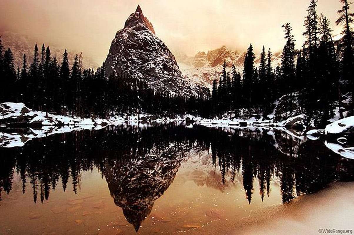
The point of going to Mirror Lake is so that I could ogle Lone Eagle Peak for the first time. Here is a bad picture of it:


But a few years ago, I recall seeing a photograph or poster of it, and immediately wanting to know the name of the peak. I think my heart skipped a beat when I learned it was in Colorado.
Here's an internet picture that does more justice:


I can't believe it's taken me this long to see it, but it was certainly worth the side trip for the vantage point (it's really a high point along a ridge). There's a class 4 route to the summit, whose coordinates I most certainly hope and expect to reach someday.


I had run out of water at this point, and my Steripen wasn't working, so I hoped for the best from the creek draining out of Mirror Lake.

Although it looked like there might be an interesting and easy scramble just to the North of the Mirror Lake/Crater Lake trail, I returned to the main trail and ran to Pawnee lake, explored the shore a bit and got off of the main trail, so I bushwhacked generally upward until I found the trail again.

Finally, I was ready for the last big climb of the day (well, last of 2!) Pete and others mentioned that the backside of Pawnee climbs inexplicably up a formidable-looking wall of rock, and this was certainly true. Somehow I ended up too far right on the talus, but once I saw people coming down I headed towards them and indeed saw a climber's trail on the talus, which gave way to a series of serious switchbacks.

And that's the reason for doing the loop counterclockwise (at least if it's your first time), because the West side of Pawnee is more of a solid climb (and worth staring at for a longer period of time!) while the other 3 pass approaches are all pretty much runnable.


Now I had just over 5 miles to descend to my car, with great weather, but it was getting a little toasty out and crowded, and I was rationing the last of my water. This was also repeat terrain for me, having hiked Pawnee Peak with J a few years back, so I wasn't too motivated and didn't move too fast.
I don't have much to add otherwise, except for it is a gorgeous and worthy loop, and I would definitely add the Mirror Lake spur. Lastly, people read these things so they can budget time (or compete! Tony's completed the main loop easily under 5 hours): I took 8 hours, with a solid 45 minutes extra for the Mirror Lake spur, and 45 minutes or so goofing around with gear or taking pictures and video, at a leisurely pace.

I think I took 60 oz of water and drank 100 oz. Since my filter didn't work, I drank from the stream below Mirror Lake. There wasn't really any fresh snowmelt or pooled rainwater anywhere. About 9 days later, I did get painfully sick for about 18 hours, but it was also after a separate camping trip in which my wife said her stomach was also somewhat upset.
I think I ate ~1.5 PB&J sandwiches (500 kcal total?), 3 or 4 gels (300-400kcal), some jellybeans (~150 kcal) and gatorade mix (~150 kcal), so probably 150 kcal/hour.

Since I recall people wondering about the comparison, that's pretty much how long I took on the Aspen Maroon Bells loop a couple years ago, with about the same amount of fooling around, although at that time there were downed trees to deal with. The extra time from that is probably a wash compared to the extra time to go to Mirror Lake, so I'm inclined to say that both classic loops are pretty close in terms of time and effort.


So go do 'em if you haven't already!

Steamboat Run Rabbit Run 100


I've been behind on the blog lately, with piles of pictures and video (which is very tedious to edit) from various summer mountain adventures that I've been meaning to share, so hopefully I can catch up on some of that soon.

I'll have more time for that during my taper, as I'm signed up for the Inaugural Run Rabbit Run 100 in Steamboat next weekend.


I'm definitely looking forward to it. Mostly, I'm excited to take a pretty chill approach to this race. Here are the things I'm most excited about, which I've placed in a bulleted list following this colon:
  • Beautiful course with varied terrain. Course loops through town multiple times, so family/friends/crew can see runners and help out with less stress, and then go about their day by having fun for hours at a time rather than stressful driving all over the place.
  • New course == no previous time expectations. I'm going to wing it and have fun and see what happens, no splits to worry about
  • Autumn colours: Could be close to peak with early changes this year. I am a fall foliage fanatic. Changing aspens under blue skies are my absolute favourite conditions, and I get out as much as possible into the trees for hiking, running, and biking during these times. J and I have made annual trips to some of the best spots across the state, yet I'm always looking for new ones. And now I can run all day (with occasional food and water stops) in these conditions? Heaven!
  • Great race director: Fred and crew know what they're doing, and although I haven't experienced their races yet, I've heard good things and enjoyed chatting with him
  • Fringes: Pizza and beer, especially with latter sponsorship including Mahogany Grill and Pateros Creek. The day the Pateros Creek guys told me they were on board was the day I was fully committed to running as well.
And on a more personal level, I'm happy to have my family in Colorado join us for crew and spectating. I'll enjoy having my in-laws cheer me on, but I'll also be able to see not only my lovely wife along the way, but also my beautiful baby niece! How cool will it be to see them when the miles start piling up?
Not only that, but my Dream Team Crew from Western States, Alex and Nora (along with Nora's sister Jill) will be helping out. I owe them as much positive energy and smiles as they give me...and for that, I know I'm ready!

Tortoise and Hare
This race is also a unique, new format in which the racing competition is split into distinct groups of "Tortoise" and "Hare." The Hare group is going to be exciting because there is big prize money on the line, with $40k being distributed amongst winners. The Hare group start time is separate, being 5 hours later. I was skeptical of this, but the idea is that people finish more closely together and it can engender a larger party atmosphere, along with the chance for back-of-the-pack runners to "see" the race up front develop later in the day. Upon reflection, I appreciate this aspect, for although many of the race leaders are great about cheering on later runners, they can only do it for so long. Logistically, it makes sense to compress the amount of time you have post-race activities.

Another distinction between the groups is that Hares cannot have pacers. I do not care for the highly-opinionated rhetoric of those that call pacing "cheaters" and my opinion is that pacing in fact historically has added to the race atmosphere and enjoyment for many, and I've really enjoyed pacing others. I respect those that enjoy having a pacer, and those that want to do it alone for any reason, but mostly I respect the ability to have a choice. So I do think this difference here is arbitrary, as I have also seen that the "elite" runners have had quite a fun time with their pacers as well (and some good stories come out of it).
I also think Hares should get a buckle, and that's my only other contention about the difference between the two.

Giving my honest thoughts on the subject, I'm kind of in a weird spot in between the 2 groups.
I've yet to nail a mountain 100 -- finishing 7-9 hours behind the winners! -- so I hope to run a more even race closer to my potential, and it'll be a fun challenge not to get passed by any Hares.
Mostly, since I do want to run with my buddy Alex, I leaned immediately toward the Tortoise group. Along with that, I like the early start, and I like the fact that over 100 folks have signed up for that wave in an inaugural race. I'm hoping there's a good contingent of folks ahead and around me during most of the race so we can figure this thing out together. I struggled a bit with the idea of finishing in an artificially higher "placing" in the Tortoise group than the Hare, but this isn't about vanity of finishing in a higher place as it is about appropriate competition. In terms of motivation and results, I think the people I'll be running with on a perfect day will push each other to a faster finish than if we were racing for ~30th place in the Hares -- just like Tim Olson's race didn't exactly push me any faster at Western States, but power-hiking up Robie Point with strangers did.
So that's my thought process on that.

This looks like it'll be a fun experiment in many ways, so cheers to a successful Inaugural RRR100!

Monday, August 13, 2012

Quick Mayflower Pilgrimage: Crystal Peak and Mayflower Hill


Crystal Peak (13852')
Mayflower Hill (12416')


After Brandon's Saturday night Leadville Run, and another great day of weather in the mountains, Nick and I, along with Andy Gisler, decided to take advantage of another mellow running/hiking opportunity before wrapping up the weekend.
First, though, we watched a replay of the women's Olympic Marathon race, drank some coffee, and hung out a bit, before finally ambling out to the mountains just before noon. But what a leisurely Sunday!

On tap was a ridge run Centennial 13er combo of Atlantic and Pacific ("Coast-to-Coast") combined with Crystal Peak. In just over 8.5 miles, we'd have a short run/hike into the lovely Mayflower Gulch, and then a straightforward Class 2 hike up to the Crystal-Atlantic saddle, before hitting C-P-A. I've enjoyed visiting the gulch previously in winter. The weather was cooperating, and we were all game for jogging and power hiking after the previous day's near-40 miles at elevation.

At least, I thought I was.

After just over 10 minutes on the trail, we bushwhacked across the creek, finding relatively easy passage through the willows and into the trees, onto the shoulder of Mayflower Hill. Skirting below it, we continued onto larger talus fields and then sidehilled below Pacific's summit, eventually getting below the Pacific-Crystal saddle. We headed up the saddle, which had one false summit lump and some impressive notchy views from the top:


And then headed up to the Crystal summit.

Somewhere along the way, though, the previous day..2 days...week's training caught up with me. Standing with both feet on a large rock, I felt it wobble, only to look down and see that it was completely stationary. My legs were not too achey, but were shaking on the rocks, and my head was swimming a bit. Not sure if one was causing the other. I ate some extra food, not feeling hungry or otherwise low on calories, but it didn't make it better. I could still move fine, just slowly. By the time I caught up at the Crystal summit, I told the guys that I was going to head down while they continued. I hated having to bail -- especially on a particular route I was excited to do -- and watched enviously as they headed up towards the cool looking notch on the top of Pacific Peak. But I knew I reached my limit for the week. If I were solo, I could have gone slower and/or taken a nap, but with group dynamics I had crossed the line from being slow to being a potential liability if I pushed anything harder (since I knew the route down was easy and would only get easier).

After a bit, though, it was actually kind of cool to watch 2 red dots proceed upward on the mountain, and track their progress. I took my time heading down off of Crystal as I kept watching their progress to Pacific. Soon enough, they disappeared around the other side.

I headed down deliberately off of Crystal, and a bit lower off of the talus and onto the tundra. Some wildflowers were still showing, and I began to feel better, enough to jog along the tundra towards the rockier saddle of Mayflower Hill. I got closer to another group that had descended off of Pacific, but I was below them near the Mayflower Saddle, so I headed up towards them. In hindsight, the quickest way is to stay low along the Pacific Creek drainage and only really climb below the Mayflower-Pacific saddle and Pacific-Crystal saddle -- essentially what Roach suggests in the 13er book.

Taking my time along the tundra and boulder fields, I was able to appreciate small details that I normally don't, such as some of the striped and smoother rocks along the creek, impressive larger pieces of quartz, and some igneous rocks as well. Along the boulders, I had to be careful, especially at face level(!), for spiders that cast a single tripwire between rocks; once the line was disturbed, the bulbous spiders dropped quickly to the ground and scurried away.

I was feeling better by the time I re-climbed the Mayflower Saddle, and I had a clear view of Atlantic. Scanning the ridge, I finally made out 2 dots just coming off of the summit, with another pair just about off of the ridge. I was happy to know of their success and being able to estimate their arrival time, so to make lemonade out of my otherwise single-summit, I made the extra effort to head up to the summit of Mayflower Hill. And, man, the 13ers are getting crowded too -- why not enjoy an uncrowded 12er?


The Hill has a faint trail on top, and a few candidate cairns vying for true summit status. I enjoyed the views from the top, knowing that I could either retreat the way I came, or ride the ridge as long as possible towards the highway. I chose the latter, and had a nice easy jog across tundra. Before dropping to treeline, I stayed high on some balder patches of grass, wanting to drop into the forest as late as possible. I feared a bit of a slog in the last 3/4 mile or so, but it turned out to be a pleasant surprise of occasionaly game trails, logging road, well-spaced trees, and otherwise clean forest floor that was relatively free of detritus. That is, it was possible to zig-zag and jog down through the trees, headed toward the highway and parking lot. I wouldn't be able to retrace these steps on an ascent, but I'd definitely recommend considering it for a return route.

I was still early enough to chat with a guy in the parking lot about various hikes, and get some beers ready for the other guys. In short order, everyone was back. I need to return for some Coast-to-Coast action another time, but was happy to have enjoyed the views from Crystal and Mayflower.

Sunday, August 12, 2012

Missouri, Belford, Oxford, Emerald, Iowa, Pecks -- Sawatch Six-Pack


Nick has already had a writeup for a week, but in any case, wanted to make sure there was interesting beta on a great route on the Sawatch.

The Missouri-Belford-Oxford trio of Sawatch 14ers is a fairly common combination of 14ers, with the peaks being relatively close together and often either done in a one-day push or by backpackers who enjoy a few days in the gorgeous Missouri Gulch. It's still a lot of vertical in terms of 14er hiking, especially considering the re-climb of Belford that is necessary to avoid significant bushwhacking, but all 3 mountains have accessible Class 2 trails.

Furthermore, for those who haven't set sight on these peaks, Gerry Roach's famous book points out that which is also suggested by topo maps: accessibility of other centennial 13er peaks, Emerald and Iowa. Thus, a 5-mountain combo, which charts at about 16.5 miles, also makes for a nice day. I've been intrigued by this route for a few summers, ever since reading it on the toilet or waiting for an appointment or wherever I typically scan Roach's book for a quick 5-10 minute glance, but there are only so many good alpine weekends and opportunities in a year.

Since some of us were headed up to Leadville for the weekend, and the weather was looking quite favourable, I pitched the idea to the Nick's (Pedatella and Clark), despite a plan to run 21 miles at night in Leadville; which, at a social pace and after a one-way shuttle, I claimed would be "free" miles that were not at risk of being un-run. Luckily, they were game for this plan.

Then I worried about pace, but there was usual talk of taking it easy, feeling a little slow, having run a 50k the previous weekend (them) or an atypically high number of miles during the week (me), etc. Everyone was kinda telling the truth, but I still dogged behind a bit...although I was the only one with a camera and taking pictures!

Anyway, we got started from Missouri Gulch just before 7am, and hit Missouri, Iowa, and Emerald first. Missouri was the most interesting of the 14ers, with more of a fun ridge than the other 2, while Emerald was the sexiest looking, in my opinion.


Next up was the only real route decision-making: heading over to Elkhead Pass. Roach's book basically suggested re-summiting Iowa. Pedatella and I discussed dropping all the way down the basin, by the lakes (I also thought about getting some water here), with the tradeoff of extra climb/descent being done at easier terrain at lower elevation. As it turned out, we just followed Clark on a direct, loose talus sidehilling slog. Other reports make note of this less-enjoyable route. It gets the job done -- and Clark was moving really well in that area -- but was certainly the least fun part of it. Coupled with running low on water later (nothing available up high), I might suggest considering the low route.

But we made it to Elkhead Pass, and soon were on our way up Belford. Without much haste, we bounced down the saddle and then up to Oxford, which had a couple of small false summits, but was otherwise a quick and straightforward scurry. Reversing our tracks, we were back up on Belford, still enjoying perfect weather. One more decision remained, but ended up unanimous, as we forewent the standard switchbacking descend down Belford in favour of "ascending" one more (named-but-uranked) peak, Peck's Peak, which is really a final bump on the North Ridge.
Besides the satisfaction of another peak, this gave us a fun extra mile ridge run, and we got to see some mountain goats we otherwise would have missed:


I poked around the farther end of the ridge a bit before descending straight down, whereas the other guys took off from the summit. Their terrain was more rocky tundra, whereas further down the ridge it was enough scree to ski a couple turns at a time (before being broken up by tufts of tundra). Other than filling up the shoes with rocks, it was more enjoyable of a descent than I anticipated.

Otherwise, my fixation was on water, as I ran out. I had only taken 2 bottles up (as had the others) as I had word that there was ample water in the gulch, but that was only in the lower parts where people were camped, so I had pushed it for the last hour, and I wanted to play with my Steripen anyway, which I had been carrying all day...and failed, again, with annoying blinking red lights. Ah well. So I wasted time doing that and finally met the other guys at the trailhead.

Anyway, it was a fun morning up high and certainly a classic route to consider to get your money's worth from the trailhead.