Showing posts with label 11er. Show all posts

Sunday, September 9, 2012

Desolation Peaks RMNP


From 2012-August Desolation Peaks Loop


Marmot Pt. (11,909')
West Desolation (12,918')
East Desolation (12,949')

Nick and I decided to check out a peak-bagging loop focused on the Desolation Peaks in RMNP. He has a more detailed writeup, but essentially we started at the Alpine Visitor's Center, shamelessly grabbed Marmot Point (a high 11er) before skirting along the Mummy Range to hit the Desolation Peaks.

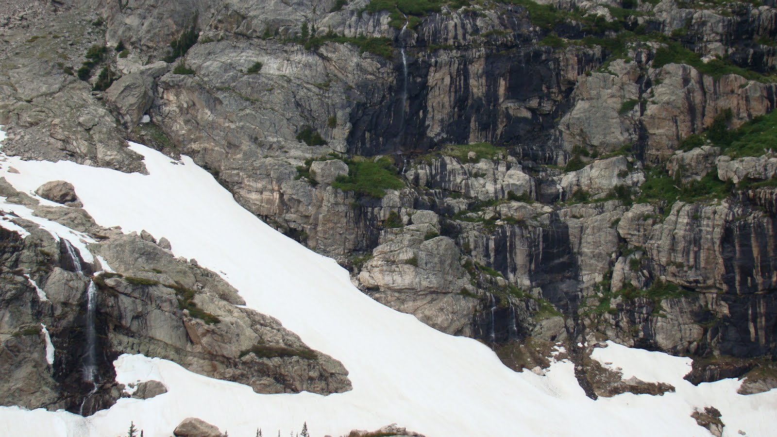
The Desolation Peaks are lesser-visited high 12ers, shyly hiding behind the Mummy's, but more jagged and pointy than the rounder neighbours. The 2 peaks are connected by a jagged, talus ridge, with the East peak being slightly higher. Fun, exposed views await those who venture here.

Unfortunately, with the exposure and significant time above treeline, weather can often be a factor. We had a decently typical forecast, and even with developing clouds, we thought the broken, blue skies in the distance would be sufficient to give us time, after a 10AM summit of East Desolation.

Soon enough, Nick felt his hair sticking up -- so that's what the shaggy ultra-mane is all about, it's a lightning detector! -- and as we descended, within seconds we heard a giant crack (more like an explosion) directly above us.

On the face of it, being on a ridge wouldn't be ideal, but it turns out the ridge has a depth of features not found on the rest of the route. Along a vertical granite wall on East Desolation, we scrambled underneath talus, which formed a rather protective and comfortable cave. We waited for 45 minutes and were relatively sheltered from rain and graupel. The close lightning seemed to be an outlier, as most other thunder rumbles were more distant, with no imminent cloud-ground flashes seen.

We killed time by making a video:

Desolation Peaks - Cave during Storm from mike hinterberg on Vimeo.


Other reports talked about exposed, loose talus on the ridge -- we were not looking forward to this, with the newly added factors of nearby storms added to wet rock (with some accumulated graupel). But being scarcely 10 minutes away, and comfortable with "Desolation Cave" as a retreat point, we emerged from the cave to examine the ridge.

Even while wet, the ridge was far more stable and enjoyable than I had read. I found the large talus forming East Desolation to be generally trustworthy and solid, both climbing and downclimbing, with great exposed views. I was motivated to move quickly because of weather, trying to get into a zone of steady climbing, and found that cracks on the climber's right of the peak provided reliable passage.

East Desolation Peak climb from mike hinterberg on Vimeo.


We retreated safely to East Desolation, with rain threatening but no further evidence of storms. Still, we played it safe by descending off of East Desolation towards the Poudre River, into the forest. Now we were relatively sheltered from weather, but spent the next hour in a longer-than-expected bushwhack.

We (meaning Nick) had initial plans of climbing a lame, forested hump of a hill that had sufficient statistics to be a ranked Larimer Peak. My interest piqued a bit when learning that it had a nickname of "Nutcracker Peak," which somehow made it more interesting than "Pt. 10855" -- but with another forested bushwhack ahead of us, we called it a day. Mercifully, the return to Trail Ridge was uneventful in terms of weather, and was more lightly-forested.

Sunday, June 17, 2012

Joe Mills Mountain: Cheap Seats in the Rocky Mountain Rockpile


Joe Mills Mountain (11078')
Odessa Lake
~9 miles roundtrip (estimate) from Bear Lake TH
~2000 elevation gain (estimate)

J was up for a moderate dayhike, and had mentioned that she hadn't been to RMNP in awhile. Meanwhile, it feels like I've hit up many of the East side trails, and I like to get up on some sort of new peak with regularity, so it was time to improvise and compromise.

I came up with Joe Mills Mountain, a lowly, barely-11er just north of Flat Top Mountain. Joe Mills Mountain is a less-popular peak, often climbed safely in winter, requiring a short bit of bushwhacking from nearby trails, but is known by those who have climbed it as being a spectacular perch to view the greater mountains surrounding it. Perhaps this is fitting to the mountain's namesake, Joe Mills, who was the lesser-known brother of Enos Mills, the "father of Rocky Mountain National Park."

Knowing that the hike wasn't too long or exposed, we began our hike at the leisurely hour of 8:30, still early enough to secure parking in the popular Bear Lake parking lot. After weaving past gapers, we were soon on the main trail toward Flat Top and Odessa Lake. After the first mile split, we hung a right toward Odessa Lake. Other than a solo female hiker, we had the trail to ourselves. We crossed one larger, hardpacked snowfield in an open space below a 12000' treeless subsummit of Flat Top, with open views of Notch Top straight ahead. Shortly thereafter, crossing a boulderfield, Joe Mills Mountain was also in view to the NNW.

The trail was as close as it would get to the south side of the mountain, so time for about a quarter mile of bushwhacking. Viewed from the Odessa trail, the summit is the end of the ridge to the left, but the right side is a more slight grade. There was a visible, open, green ramp to the right of the saddle. Other options included sections of talus of unknown stability, and trees. Plenty of trees. We headed vaguely for the right of the saddle, alternating steep upward trudges in the trees, with traverses around them (and to avoid occasional sections of larger boulders) and along faint game trails, but never quite reached the open area spotted from below. But with only a few hundred feet to gain, mere upward movement got us their quickly enough.

We were only a short tromp away from the saddle, an open grassy area that was already a nice place to visit, and perhaps picnic. But the summit was still close. The only thing holding us back was krummholz -- and it was thick.

Progress through the brush was occasionally stunted, requiring slight backtracking and scraped legs, but in minutes we were on the summit ridge.

Indeed, the views were absolutely stunning. Notch Top straight ahead, snowfields on either side, and Little Matterhorn and Gable Top to our right, with Lake Helene and Odessa Lake reflecting the sky below. A small register jar suggested we were the 8th party this year (to be fair, some winter summits may have gone unlogged in deeper snow). Alone, together, we spent a good 20+ minutes of perfect, windless weather on the summit. Several waterfalls thundered and echoed below.

Most of what I knew from the summit ridge, and the northwestern side of the mountain, were abstract notions from the topo map. In person, it looked like a quick, steep Class 3 to open tundra, and if we headed northwest, we could stay along a treed spine of tundra, talus, and scree, giving us plenty of options that were all much more open than more bushwhacking. And the trail itself came close to an open boulderfield below.


I tried to convince J of this suggested route, which I honestly believed would take no more time but be more interesting and show us new terrain. "Besides, it's much more satisfying to climb over a mountain," I'm pretty sure I said. She was game, as long as the rock on top wasn't loose. I went ahead of her to check: solid. Plenty of options. We headed down just below the summit cairn.

We zigzagged on steep tundra for a bit, among budding wildflowers, heading northwest toward the open ridge that ran down to the ridge. Steep trees were always an option, but we were able to remain vertical on the talus and surfable scree.

We were now back on the smooth trail. J turned right (away from where we came) without me saying anything -- apparently she was also game for visiting Odessa Lake, since we were "right there." Awesome.

Another bonus of this section of trail was that Joe Mills Mtn. looked more interesting and significant from this vantage point (first picture). Although we were still a ways off, we had a closer look at Grace Falls and other sections of weeping granite below Notch Top.

We then descended gradually to the north (far) side of Odessa, after thinking we would have reached it earlier from the south. A small bridge crosses Fern creek that feeds into Odessa. And, then, a mind-blowing perspective of Little Matterhorn.

I've since learned there's an exposed Class 3/4 route up the back spine of Little Matterhorn. I want to return.

Clouds rolled in as we headed back, and light rain, but nothing threatening. The clouds just added to the atmosphere.


Without seeing many people, we felt like we had ventured deep in Rocky Mountain, despite being no more than 4 miles from a popular trailhead. This illusion was dispelled while dodging people stopped in the middle of the trail in the last half mile, but it was very nice while it lasted. I hesitated to post much about this hike, because the payoff in views is so high. It just takes a little bit of off-trail exploration. And overall, it ended up being fully wife-approved.

Summary
"I'm visiting from (insert state) and climbing Longs Peak -- what should I use as an acclimatization hike?" is a common question for visitors.
Twin Sisters is a common (and good) answer. I'm not as much of a fan of Deer Mountain and Estes Cone (other popular answers), although they're fine, lower mountains; Meadow Mountain would be my next Class 2 suggestion. Flat Top Mountain has a great trail as well, but is a little more popular and busy.

Joe Mills is another answer for those looking for an easy taste of a little bit of everything, and for practicing just a bit of off-trail hiking: not too far, spectacular views, relative solitude, relative safe routes for winter, light routefinding and bushwhacking, and opportunities (but not necessity) for Class 3 and possibly Class 4 scrambling on top.

Sunday, October 16, 2011

Red Feather Lakes "Triple Bald" Loop


North Bald Mountain (10982')
Middle Bald Mountain (11002')
South Bald Mountain (11007')


Looking for something mellower, and with wind moving into the high country, it seemed like a good day to head to Red Feather Lakes.


No I-25, no I-70: just a mellow drive up north. (Or bike ride: it's just over 50 miles from my side of town, and made a nice out-and-back century a few summers ago).

Staring at maps west of town, on Deadman Road (note: this is CR86, not 162 as denoted on the Trails Illustrated map), I decided to check out an interesting loop combining North Lone Pine trail and Killpecker trail.. The trail loop itself can't be more than 12 miles or so, including a couple miles on the dirt road to join the two. But just off of these trails are some prominent peaks of the Laramie range, worth some off-trail exploring. The highest named peaks -- North Bald Mountain, Middle Bald Mountain, and South Bald Mountain -- poke just above treeline, giving great 360-degree views.


South (Left) and Middle (Right) Bald Mountain, seen from North Bald Mountain

North Lone Pine trail is a steady but pleasant climb in the trees. After running for about half an hour, the trail took a left and started descending slightly/flattening out. At this point, I suspected North Bald Mountain was above, to the right/West, but didn't have a direct view of it. Nonetheless, I began the bushwhack upward.

The lower part of the slope was more open and had less deadfall than other dreadful bushwhacks in Northern Colorado, but just as I was getting content with this fate, a bit more rocks, trees, and snow appeared, slowing things down a bit, but still quite manageable. Soon enough, daylight poked through the trees: except for a bit of rolling terrain, I was on the top of North Bald Mountain.

This afforded nice views of Middle and South Bald Mountain. Unfortunately, it's another descending, and then ascending, bushwhack over to Middle Bald Mountain. At least it's easier to find via dead reckoning, and although not easily runnable, it didn't take too long to get up there.


Middle Bald had more interesting rock formations and scrambling opportunities on top. I took in the views, and then slowly downclimbed on large, solid boulders, toward South Bald. In retrospect, it would have been easier and quicker to drop down the mellow backside to the Killpecker trail.

I headed toward South Bald, knowing that a few trails were down below in the thick of trees, but that the trail can be subtle in some of the thicker spots. I hit one of the trails (North Lone Pine, again), but inexplicably headed the wrong direction: I happened to hit it when it made a short bend, heading downhill, which at the time was the direction of my goal, before it headed very much North again.

I recognized my mistake after 10-15 minutes, turned around, and then re-questioned my initial decision about which way would really be the best. I wasted a good 30-40 minutes running back and forth a few times and double checking the map, but once I was on track, I found that my original intersection of the trail was within 3 minutes of my goal: an intersection with Elkhorn Baldy Rd.

Back on track, I headed up toward South Bald, taking what I think was the Swamp Creek cutoff. (Things get a bit questionable back there when offroad vehicles make their own trails). Nonetheless, it was easy and obvious to climb up to open areas and get clear views of South Bald.

South Bald is the highest of the named peaks, and is an enjoyable, quick climb. But I didn't spend too much time in the wind before retracing my steps back to the Elkhorn Baldy intersection.

Now it was time to check out the Killpecker trail. Although at similar elevations as North Lone Pine, these aspects held a few inches of consistent snow, which was enjoyable to run in.


I could even make out faint cross-country ski tracks! Somebody already got some skiing in. I've read about these trails in Snowshoe guides, and Killpecker is especially nice because the rocks aren't too large on the trail, and both trails are mostly protected from the wind. For some possible turns, the backside of Middle Bald, and possibly South Bald, are mellow-angle and north-facing. I'll definitely be back to check it out in winter!

I would recommend the loop as a run, as both trails are quite runnable and enjoyable. Bring a good map! Further exploration may include some of the lower "bald," rocky points sticking up in the area. Otherwise, Middle Bald is right off of Killpecker trail and easily accessible, and South Bald isn't too much more of an effort -- I'd recommend those for great views. North Bald might not be worth the effort.


Sunday, October 2, 2011

Meadow Mountain Hike in Allenspark


Meadow Mountain (11632')
~7 miles RT, 2700 ft. gain from St. Vrain TH near Allenspark, CO


My bride and I decided to spend a fantastic fall morning with a more leisurely hike up Meadow Mountain near Allenspark. I had spotted Meadow Mountain and its higher neighbor, St. Vrain Mountain, during recent forays into Wild Basin. Since the area appeared to be near-peak in terms of foliage viewing, and the summit would provide fantastic panoramic views, it was nice to minimize driving on I-25 and avoid I-70 altogether. Finally, I would get to check out yet another trailhead and trail, having recently decided there's no reason not to visit every single trail in the park at least once.

Both St. Vrain Mountain and Meadow Mountain are less-popular hikes, but much of the hiking information I do find is in regard to snowshoeing. Undoubtedly, with ample snowfall, the great views and relatively safe approach on the mellow angles of these slopes make it a great choice for winter excursions. In fact, the St. Vrain TH is a turnoff near the end of Ski Hill Road in Allenspark, which is historically named for several ski areas which used to be in Allenspark. Now, the community is a very quaint outpost near RMNP, tucked off of the main Peak-to-Peak highway. It gets almost none of the attention of its famous neighbor to the North -- Estes Park -- yet has more than twice the charm, and is worth a visit any time of year.

The hike is a typical forested creekside trail with a steady climb to treeline. The aspen are immediately stunning near the trailhead, with some brilliant orange on display:


A hike in Fall continues in colourful splendor as the trail leaves the forest for open meadows of deep reds, and distant views of amber leaves below:


So far, the hike nicely met J's requirement of being "Over the River and Through the Woods," which means mostly on trail, without long slogs on talus, snowfields, scree piles, etc., as it approached the saddle and National Park Boundary (having crossed through IPW) at a saddle between Meadow Mtn., some unnamed points just above 11,400, and St. Vrain Mountain. We had planned on a decision between Meadow Mtn. and St. Vrain at this point. Prior to the hike, I was secretly hoping for the "higher-is-better" choice, but seeing the two options in front of us, I imagine words like "steep," "talus," and "krummholz" being thrown about as curse words should we have chosen St. Vrain. Truthfully, Meadow Mtn from the saddle was an appealingly short hike that was mostly tundra, with just enough talus to be fun but not annoying, and would give us better views to the North. Easy decision.

With extra time at the top, low wind, and sufficiently warm temperatures, we lounged around a bit with the summit to ourselves, nicely able to celebrate our 9th anniversary from earlier in the week:


The broad summit had no visible marker or summit log, but has an electric box with a solar panel and antenna, and otherwise sublime views in every direction. We were in no hurry to leave the summit, with only gentle clouds in the area.

In all, this was a spectacular fall hike, even better by enjoying it together, and I can imagine returning for a bluebird winter day. We hadn't left the trailhead until almost 8:30AM, yet had only seen 2 other people on the trail, and took plenty of time for foliage pictures. On the way down, we did see maybe half a dozen parties as the clouds began to roll in. I hesitate a bit, but this hike is a great suggestion for foliage viewing and acclimatization hiking for visitors. It is similar in difficulty and elevation to the much more popular Twin Sisters hike (also a free-parking TH that accesses RMNP), yet has better views and much less human traffic.