Tuesday, December 3, 2013

'Til Next Time, Fort -- Part Deux

Seems like I need some sort of transition before moving on to blogging about nonsense from a new locale.

So we're settled into Golden, now -- Denver West, actually, on the border of Denver and Golden.  And Denver West, actually, is itself a registered trademark (since 1982), as I learned via the circled "R" on some park benches I saw the other day.

But I digress.   J has a new job in Lakewood, which is a great opportunity for her, and so moving south made sense for both of us, to also make it easier for me to get to the Anschutz campus.

We left Fort Collins once before, for just under a year, before moving back -- who knows if it will happen again.  We absolutely love the town, the community, and our friends.  It is the first time, having lived in 4 different states together and twice as many towns, and a strange feeling, to be missing out on the present and future of the city.  We've both worked and volunteered in various capacities in the community, and feel like we've had a great stake in it's successes and challenges.  We've put a lot of work and pride into the town, and into our first home.  I've put thousands of miles of shoe and bike-rubber all over the city -- I'm unaware of any roads or natural areas I haven't visited.  We've watched countless sunsets from our patio, and numerous sunrises from the dams or Horsetooth Rock -- the latter of which has traces of my blood on it.  No other place is more integrated into our history and identity than Fort Collins.
 
The community involvement, and especially things like the bicycling infrastructure and school involvement (albeit with the normal Colorado challenges of funding) are exemplary.  
Unfortunately, job prospects for 21st-century careers in biotech and health analytics (e.g.) are better in the Boulder and Denver area.  I hope that Fort Collins can attract and maintain major employers in those areas, and the ability to utilize a young, talented workforce remains the major challenge. 

That is only to explain our reluctant and perhaps temporary leaving of Fort Collins.  Otherwise, we are fortunate to have made lifelong memories and friendships.  With family still in town, including my favourite niece, we'll undoubtedly be back regularly.  And we're renting out our condo, which is also a reward in itself.  

As for a running standpoint, there's much I'll miss.  Definitely many of the trails, rocky or paved, and many of the workouts, like Jane's Tuesday morning or Towers (umm, maybe not as much lately) and my favourite bar, the Trailhead.  But mostly, the people: genuinely good folks that have given me good reason to get up early, stay up late, and trudge through all kinds of weather.  Everyone's too numerous to name, and that feeling is quite a blessing.

So I'll miss you all, Fort Collins!  But we'll be seeing you around.

Thursday, November 21, 2013

Snow Bike, Fatbike, Ice Bike: What's in a Name?

The epic Front Range Winter of 2006-07 

Today's taste of winter reminded me of confusing winter bike nomenclature.
Here are some facts.

Snow Bike
There is a thing called a snowbike:

Generally and historically, it has one or two skis, and is also known as a "ski bike."
The original (and registered trademark) snowbike is found at the Austrian website for snowbike http://www.snowbike.com
As the top google search, one of the bikes is noted for it's best all-around FahreigenschaftenIt pleases me to know this word exists for "handling characteristics."
But speaking of translations, it seems this should have been called a ski bike only.  It's not a bicycle!  At least, there's nothing "cycle" about it.
There are versions with a rear wheel, but the double-ski version are mostly used on ski slopes at resorts.  I can see the use for those with limited mobility to get down the hill for sure: rock on.  But otherwise they lack the Fahreigenschaften and full-body workout and flow of real skis (I imagine, without actually trying them), and they take up extra space on ski lifts.  Mostly, it is annoying because the "snowbike" set off an avalanche of suboptimal bike-naming.

Skiing and biking together...I prefer this way instead:

*
Ice Bike
So what about people that want to ride or commute in the snow?  A good way to do this is with the increased traction of studded tires.
With "snow bike" taken, these bikes became known as ice bikes, which certainly are better for riding on ice, although riders are generally more enthusiastic about riding on snow.  And we generally call studded car tires snow tires instead of "ice tires."

Here are some folks riding ice bikes in Poland:


Many good products, projects and inspiration is described on http://www.icebike.org/
I spent a few hours and a box of screws a few years ago making my own studded tires.  They worked great on packed snow and ice.  Otherwise, I was terrified about having to fix a flat by peeling off a stiff, spiky tire in the cold; or causing a flat because of all those screws pushing back in against the tube while riding on pavement.  And the tires were heavy!  It was a fun project to do once.
Commercial tires like Nokians seem like a more reliable bet, and it would be even more convenient to have an extra set of rims to swap as necessary.

While wider tires are generally better, I would argue that there are some very specific snow conditions (grippy, wet snow -- e.g. a sunny afternoon just after the cold front passes through) in which road bike tires slice through the snow instead of floating like fat tires do.

*
Fatbikes
But what about deeper, powdery snow, and trail riding? 
This is where fatbikes come into play.  These are bikes with extra wide tires.  Extra wide tires require extra-wide rims...which require extra-wide forks and brake clearance.  And an extra-wide garage, because the owners probably started with a few more standard bike styles and are reluctant to get rid of them.

Some guys were making their own fatbike modifications, but it really took off with Surly Bikes, when they released the Pugsley:

This has become popular for snow (and sand/beach) trail riding, and races like the Arrowhead 135 and Iditabike.  Some also argue that lower pressure also means less trail damage (in alpine areas, etc.)

Anyway, I do not own a fatbike, and this bothers me.

*
Fat Tire Bikes
Still, this is a bit of a confusing name because fat-tire bikes were used to distinguish, well, bikes with fatter tires, from skinnier road tires.  
This also inspired a popular beer:


Among fat-tire bikes, it's a bit confusing because fat tires (or balloon tires) were originally found on heavy, town-cruiser "klunker" bikes, until re-appropriated under separate circumstances by legendary folks in Marin County, CA and Crested Butte, CO.


This, of course, led to the development of the mountain bike -- which is no doubt ridden on or in the mountains, but in popular use is statistically more likely to be found on trails or roads that may be nowhere near any mountains.

That's still better than...

*
Flat Tire Bikes
That's what's most likely in your garage right now.
What's your excuse?


Thursday, November 14, 2013

Leadville: It's not just the money

Leadville-haters have spoken.  And the fanboys have spoken.  We're all better off because all of this is amusing.  It looks like the race series is looking to make some changes.  I'm optimistic about this and hoping for the best -- let's see what happens.

But is there any room in the middle?

There's a fundamental issue that I think is missed: several folks have made the point about how much money the race brings to town, or how much they personally spend on it, and how they're willing to spend even more on it(!) before seeing any actual changes.  People use these arguments to justify the implementation -- and flaws -- of the race.  A common variant of this:
"If you don't like it, spend your money elsewhere."  This is an insufficient argument when analyzing anything other than a choice of benign options (like debating beer brands or bad movies) -- especially when some of the criticism and negative effect is felt by people completely uninterested in the race.

A strict monetary analysis is neither necessary nor sufficient.  It's possible to have an event in town that is break-even but brings positive attention to the town, or increases sense of community (e.g. town fireworks displays or parades); it's possible to bring money to a town in a way that is toxic.  Perhaps it's a bridge too far in a philosophical divide -- maybe a gap as wide as the distance from Leadville to Silverton -- but merely bringing money to a town needs to be balanced against the negative externalities as well.  Some of the locals (the town of Twin Lakes, businesses like the Golden Burro; disinterested hikers and fisherman; howling packs of roving dogs, whatever) are unhappy, or at least inconvenienced, with the race, or at least the size of it.  Leadville run has no cap -- how big is too big?  I don't know, but it's insufficient not to consider the question.

Many modern business practices, and communities themselves, consider the triple-bottom-line: financial, social, and environmental impact.  Meeting all 3 of these generally leads to a desirable, sustainable situation.  In fact, I would strongly argue that the Chlouber's initial implementation was a shining example of this: mine's closed, but there was already some dependent service-industry and infrastructure dependent on it, and the race was so small so as to have had little environmental impact (certainly much less than the mine itself).

So what happens when you make a decision solely on money?  You get unsustainable implementations.  Various business interests and models need to be tailored the community, but the answer of "Well, it brings in money!" is insufficient.    Mining, fracking, drive-thru's, casinos, and strip malls have their place (well, just kidding about drive-thru's), and on a strict balance sheet, they bring in more money than wilderness, especially in the short term.  But try to think a little higher and deeper.  
Quality of life, and community, is not so easily monetized.  And some people spend more than others when coming to Leadville.  That's fine.  Bring an entourage.  But do campers (Clark?  Tony?  Lucho?) count less in this scheme?  Does the lifelong resident with the modest shack count less than our Front Range invasion?

And it's even worse to suggest that unsustainable practices like treating the National Forest as a parking lot and garbage can is worth it because of the money.  The Winfield situation doesn't bother me as much as an "ultrarunner," (whatever that means), or from having done the race (running it once and pacing 2 years)...it bothers me because I'm a Coloradan, and I've spent as much time camping or hiking out there with my wife than I have as part of the race.  It's a beautiful part of the world, but it looks like a suburban Walmart in August.  I much look forward to being an old man leading kids up Huron or Hope Pass rather than talking about a belt buckle.  I think it's perfectly valid to have a vocal opinion on the race, representing concerns about sustainability and image, and  the locals that aren't involved in the race, than merely taking my money elsewhere. 

Look, I get that some people like (or love) the race.  In all honesty, so do I.  Which is why I support the "tough love" and asking hard questions.  It's easy and natural to think and do something because of a personal opinion, but it's more admirably higher-minded to look at the big picture and see how it affects everyone, even if it means making a personal sacrifice, like not committing to running the race until proper changes are made.  The storied history of the race, and the many good things that come from it, do not make the race immune from any and all introspection and criticism.  The race can be fixed, and it looks like steps are being made, to meet the needs of the running community as well as the larger community.  But it can't be judged strictly on dollars.  Natural spaces, an examined lifestyle, sense of community, and ideals are far above the simple calculus of money.

Or a belt buckle. 

Tuesday, November 12, 2013

White Rim-in-a-day (WRIALAD) Bike Ride


White Rim in a Day (aka "WRIAD" or "WRIALAD")
14 hours, 103 miles

*

Canyon country: canyons beyond canyons of geologic handiwork, carved over epochs with remarkable patient precision.  Think of the naivete of quick perfection being fully formed! -- when compared to the careful chiseling of rock into even more rugged and imposing character -- falling deep from a higher plane, with levels of complexity revealing the history of the making like so many books.

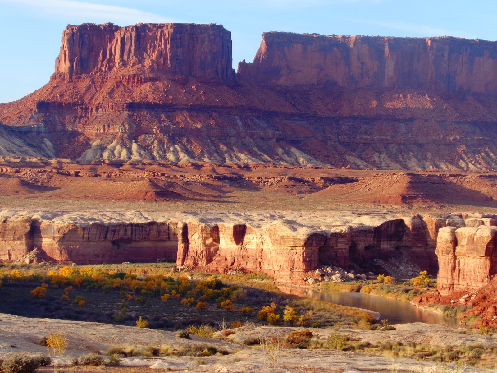
Canyonlands National Park comprises but a part of Utah canyon country, with the Island in the Sky District providing a grand view of the confluence of two of the most important rivers of the American West.  This is Abbey country, along the Colorado, as well as the Green, with eons of destruction creating a complex landscape. The distinctive white rim -- visible from space but even more accessible from a perch near the park entrance -- frames the fractalized contours of the plateaus below.  

I had the pleasure of viewing it from above, on a trip with J almost exactly a year ago.


The White Rim trail, then, follows along these impressive mesas, with occasional switchbacking drops down into the level below.  As a rocky jeep road, the 103-mile circuit is an American classic, often done in multi-day camping trips involving jeeps or mountain bikes.  Of course, the distance and challenge also lend itself to a single day effort on a mountain bike or a jeep.

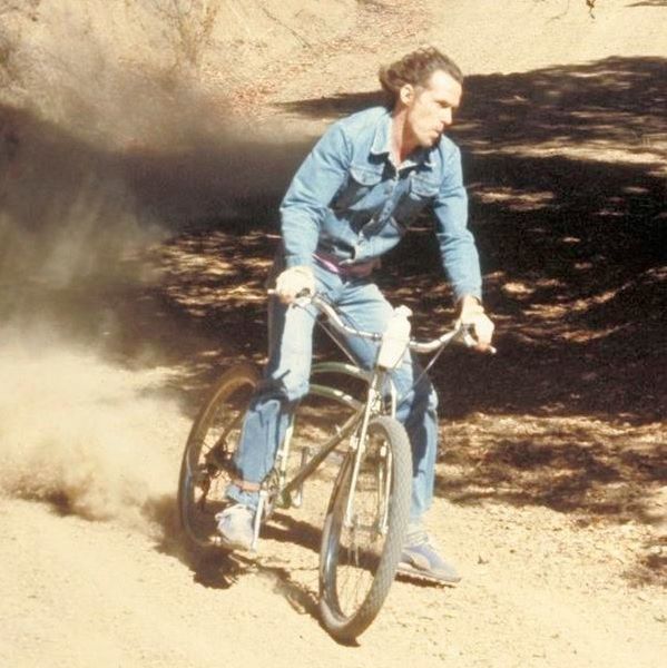
Alex and I were happy to give it a go.


*

As you can see already, it was a successful attempt, leading to a satisfying GPS track which traces a solid artificial line on top of where a road is, with accompanying quantitative statistics.  While riding in a day is certainly a difficult challenge, others have run it instead, and mountain bikers have done it twice as fast.  (Think: aero bars, drafting, van support).

Assuredly, Alex and I did it with uncertainty, minimal planning and preparation -- "White Rim on a Whim" -- and had a fantastic experience on a beautiful day, getting our money's worth with several hours of dawn and dusk riding.

We began with the drive from Colorado on Friday afternoon, arriving at Mineral Canyon Road after sunset, with vague hopes of camping on BLM land.  We followed the dusty, washboarded road for nearly 13 miles, knowing that we'd be returning up the same road around sunrise the next day, surprised at the lack of other vehicles, bikes, or visible camps, before the final pulloff above the Green River.  It was after sunset as Alex drove down a steep, ledgy road with little room for error (or anywhere to turn around), so he proceeded mostly on faith that the road would indeed get us somewhere useful.  We first saw the actual road in daylight 2 days later.


It was fully dark when we hit the bottom, and after a left turn and a scant several hundred feet or so, we saw a sandy pulloff to the right which led fortuitously to a campsite with an arranged ring-circle for a firepit.  Being the first available candidate we had seen, it was the perfect spot.  Again, it was a full 2 sunrises later that we actually saw how beautiful the site was, being right on the Green River.


As far as we could tell, we were the only ones camping down by the river.  We made camp and dinner quickly, and fidgeted with bikes and gear.   Just before retiring, we saw headlights coming down the switchbacks, which eventually pointed near our campsite.  A couple guys got out and scouted around, and just as we thought they were leaving, they re-parked and began setting up camp.  Ethan and Josh.  Climbers.  

I've had enough rowdy camping neighbour experiences to fear the worst, and I bring along earplugs just in case, but it's a frustrating alternative to a peaceful camp.  Sometimes, or even often, free camping is even louder than Disney-esque established campgrounds because there's no accountability or authority.  But, so far, these guys were respectful, talking in hushed voices, and closing the doors on the truck -- closing, not slamming! -- quietly.  So I also thought about those looking-in-faith-for-a-campsite moments where I'm just hoping to find a small patch of ground myself under a starry sky, and it was even better to share the landscape with kindred spirits.

I walked over to introduce ourselves, and offered some beer, which they obliged and remarked on the Fort Collins origin.  Turns out, they were from Loveland area and now one of them was in Durango, and they were out to climb Moses rock the next day (a prominent tower on at least one list of "Fifty Favorite Climbs").  They were apologetic for camping nearby, and we were quick to appreciate their concern and respect out in the desert.  They also showed us the success of their "Upside-down fire" -- an interesting thing to consider for future fire efforts, and certainly an archetypal fascination in general that I'm sure is encoded somewhere on the Y-chromosome.  

As we told them of our bike plans, it was interesting to think of their orthogonal plans, moving hundreds of feet vertically, through great effort and risk, while barely budging on the map, while we were doing the exact opposite.
And now you see, if you haven't already, how senseless maps really are!

*

So now I'll tell you a bit about preparation: the plan started when the womenfolk planned a girls' weekend out in Santa Fe.  I wasn't even sure if Alex was available, and had a mental checklist of options but kind of wanted to see how the weather was fairing.  Two years ago, in fact, a group of us had a great time and perfect weather in the Grand Canyon, so it was natural to be drawn to the desert again.  But I wasn't sure about a similarly long on-foot effort, and neither was Alex.  Even when I was thinking about the bike ride, of course, the government shutdown threatened the possibility through half of October anyway. 

Still, I figured the Gravel Grinder a few weeks prior was a good shake-out, with a few shorter mt. bike rides here and there.  Alex had done a road century in the summer, and I was sure relentless stubborn progress could get us through anything, but I hadn't really warned Alex about the specific idea, and I think the idea was mentioned after a beer or three at a Halloween party, when I didn't even know very many details about the ride.  So I was pleasantly surprised (well, not really surprised) the next day when he texted after reading ride reports and watching videos: "I'm in."  

Other than a few rides, I also started thinking about gear a bit, and most of it worked quite well.  So here you go:
* 29er hardtail (Trek/Fischer Cobia)
* 1.9" semi-slick tires (Geax Evolution, cheap from REI)
* Downtube bottle cage: hose clamp, with tire tube rubber
* Rear rack: Schwinn seatpost mount (cheap from Target), bungee cords
* Seatpost cage: zip-tied to rack and seatpost


I had a Mountain Hardwear waist-pack with 2 more bottles, so 6 bottles and ~130 oz's total (on a cool day, 30-55 deg F).  I hate worrying too much about gear, but had fun with the fact that relatively modifications worked well at keeping weight off my back and shoulders.  The rear rack was tight and didn't sway at all -- I just could have used another strap on the rear bag (extra layers) and rear bottle cage that was a bit loose.  The tires were great as the route doesn't really need knobbies at all, and the lower bottle cage was great as well.  And there you go, for the accounting.  

*

Anyway, we awoke to cold and dark and frost.  The advantage of parking at Mineral Bottom, and proceeding clockwise, is getting one of the largest sustained climbs out of the way early.  Without daylight to marvel at the views, it was easy to focus on the thin beam of headlight, one switchback at a time.  I through it into the granny gear right away to spin more and, uh, stay warm; and by getting that out of the way, I didn't have to think about trying every climb in the middle ring or other such foolishness.  (Later, plenty of other opportunities of sandy, steep climbs made me grateful for the granny gear as well).

After 20-25 minutes, this was followed by arguably one of the least scenic stretches  (a gradual climb through high-desert brush) in low light.
For "not scenic," it was still a great place to be.  And we had a big climb out of the way.


We had a manageable but cold, sharp headwind, so we were anxious for the rising sun.  That only helped a bit, as we entered the National Park through an unmanned station.  We tacked on the extra mile each way to visit the Visitor Center and pay the entrance fee. Did I mention, we still hadn't seen other riders yet? We figured it would be a popular enough weekend that we'd see several groups around sunrise, but hadn't yet seen any.

I refilled the scant water that I drank already, and tried to warm up a bit (I had 2 unused layers, still, but it was colder when not moving).  As we talked to the rangers, we were told in no uncertain terms that it was a long ride without help or water, that the days were short and it was already 9AM, and that we'd be finishing in the dark.   Yeah, I know that, say, Grand Canyon R2R2R is discouraged, but we had plenty of water and gear (enough to spend the night or more, if necessary), and already had 20-some miles done; so how about some encouragement instead?
(Later, by only seeing about 5 other vehicles all day, I realized how un-busy the park is, ironically, outside of the hot summer season, so even being on the road is more removed than being on any road in Rocky Mountain NP, for example.  At worst, it seems one might be 20 miles or so from water; in some cases, the quickest escape route might be one of the crisscrossing hiking-only trails that lead back up a thousand feet or more to the Visitor Center).

So our next order of business was dropping more than a thousand feet into Shafer Canyon, on a switchbacking jeep road.


This certainly could be a bomber descent, and would be even more fun on a full suspension bike.  Disc brakes are certainly helpful.  As it was, I tried to force myself to stop grinning so as not to get dust and grit in my teeth -- but it was hard.  We took it easy and enjoyed the views, and I stopped to adjust and double-check the gear strapped to my rig.


I heard a voice from above, which would have been tourists from one of the overlooks.
"Oh, wow, I have something new on my bucket list," said the voice to his friend.  "Check out those bikes down there!"


We made our way down to the next thematic section of the ride: long, flat riding surrounded by monuments and canyon walls.  The weather was great for riding but still just a bit cool.  Within a few miles, we would be coming up to a short side-hike to a spectacular rock bridge known as Musselman Arch -- we were looking forward to this as one of the highlights of the trip.

Musselman Arch is flat, solid -- and no wider than a sidewalk, with a steep dropoff on either side.  But it's accessible for hiking access (in years past, people have taken bikes and even motorcycles on it), giving a unique and fantastic vantage point.

Not wanting to walk in bike cleats for various reasons, I asked Alex to take pictures while I jogged barefoot on the rock.


We both took turns out on the arch, and enjoyed a chance to thaw out our numbed feet.


Back on the bike, then, we enjoyed impressive views of sandstone monoliths, with the frosted La Sals in the distance.


As we rode further, I remembered one of the more unique rock names that I had seen on the map, and we saw her plainly and obviously: "Washer Woman Rock."


We continuee flat riding in a land of stone giants, alternating between flat, sandy valleys and slickrock ledges.  Despite descriptions of backpacking campsites being full months in advance, we found most of them empty despite nearly perfect weather.

We kept our eyes out one more major stopping point, "Vertigo Void," which is an undercut section on which the rim is roughly a foot thick at the edge and then only gradually thickens as it retreats from the large void hundreds of feet below.  Supposedly, lying above the void presents the sensation of flying, especially when the wind updrafts from the canyon below.


We approached the edge, with little to no wind.  I'm not sure about flying, but the vertigo part was definitely true: if I focused my vision away from the rim so as not to see the edge holding us up, my legs spasmed and my heart raced to remind me that it was still on solid ground.  A bit of somewhat terrifying fun.  I like to envision that we -- animals -- have an unappreciated sense of gravity, and that we can feel the minute differences between solid objects and voids, between heights and depths (distance squared), perhaps via tiny, unstudied sensors within our bodies; and that this affect is blocked or muted when encapsulated within larger objects, like buildings or cars.
Without proof, though, it'll have to be considered imagination.  Or faith.

And then, more riding.  We encountered occasional groups of cyclists:  with a trailing van, and some spry freshness and odd line and cadence choices, most of them were out for a supported section ride.  Hopefully the smiles and fun are a gateway to further riding.  A few smaller groups did appear to be in for the whole enchilada -- but definitely a much less frequent endeavor than Grand Canyon through-hiking this time of year.

We had a few climbs left, namely Murphy's Hogback and Hardscrabble Hill.


Both are short but steep grunts -- more runnable than rideable -- with a bit of sand and ruts to make things interesting.  And on our ride, these climbs came about mile 70 and almost 90.
A surprising short section before Murphy's was sandy enough to hop off the bike for a short section.  But the climb itself was the right aerobic challenge, as I fought my front tire just barely hanging on to the trail, and used every bit of tiny relief sections of flatness to catch my breath, between intervals of 30-40 second anaerobic grinds.

I didn't get good pictures on the way up, but the view from the top was rewarding.


We enjoyed a fun descent after all that work, and finally were able to appreciate our net decline towards the Green River, with a surprise treat being the sheltered trees still hanging on to golden leaves.


While the dropping sun meant we were running short on daylight, it was an absolutely sublime and mesmerizing set of sunsets.  We were treated to a ride towards a prominent sundog -- three sunsets for the price of one! -- while shadows and reflections upped the visual ante.


And so we were tired and nearly ready to be done, but witnessed some of the best scenery at the best time.


Shortly after this was some fun, hardpacked cruising.  Finally, full dark, with a clean climb of the switchbacking Hardscrabble hill, followed by sandy rollers in the dark.  Trying to anticipate sand was more difficult with limited view, and even after we descended back to the nadir of the ride, the sand, fittingly, forced us to a walk.

And then the "other" entrance, which had a leather-bound book full of not just names and dates, but other assorted prose.  With cold, cramped fingers, I scratched our names on one of the pages.


Just a few more sandy miles, and we were delighted to see our campsite again, in full dark after over 14 hours.  Ethan and Josh had their fire going after a successful climb, and cheered our return, and we made quick work of opening beers and cooking any and all edibles we had.

*

This was a fantastic ride and Alex was the perfect partner for it, it would have been a much darker experience without him.  We were quite happy with the choice to ride clockwise and to start from Mineral Bottom.  Along the way, I thought of how something like Kokopelli Trail (140+ miles) in a day would be more miserable than my armchair enthusiasm would have predicted, and how comparatively un-fun riding in the dark is (perhaps it's lack of practice, but the "speed penalty" of riding in the dark is much worse than running).  Although not technical, I can't imagine running it -- my hat's off to those that do (not much slower than we rode it!) -- but even with the mechanical advantage of a bike, it was even more satisfying to be "out there" in the distant part of the loop without any knowledge of any sort of nearby rescue or support vehicle.  It was nice to be done with the ride, and we certainly thought about how much faster we could ride it; but we both agreed, if we did the loop again, it would be even more fun to do it more slowly, with even more time to explore the ample campsites and side trips.


Video summary from Alex:

Thursday, October 24, 2013

Front Range Gravel Grinder: A Weekend in the Springs

Colorado Springs Weekend

J and I had a great time last weekend down in the Springs.  We saw a few different friends, and enjoyed a few breweries:
The latter was my primary outdoor focus for the weekend, with a chance to ride a scenic, rolling 46-mile course with friends on a gorgeous day.  It was free, and did I mention it began and ended at a brewery?

So the Front Range Gravel series is a new series to capture the fun of gravel-grinding, which mixes up courses that include singletrack and dirt roads as well as paved ones.  Longer events are popular in midwestern farm areas that have plenty of rolling dirt roads, and some argue that perhaps less popular in Colorado, which has sublime roads for road racing, and equally sublime trails for mountain biking.  However, Boulder's "Dirty Bismark" and even the informal "Winter Ralleye Rides" up in the Fort have a bit of this spirit as well -- riding the dirt opens up even more terrain for exploration.

This begs the question of bike setup choice.  Fast and light cross setups are certainly the popular choice, but touring road bikes as well as mountain bikes work just fine.  
Although free, and on an unmarked course, this was a timed "race" -- I was happy to meet up with JT, and by riding it for fun, it was a good choice to go with the mountain bike.


A few tweaks: 1.9" semi-slicks; mapholder, camera, and horn on handlebars; PP Brewing Devil's Mountain Red in a can.

I hoped and thought it would be laid-back, and it mostly was, but it was "Colorado Laid-Back" with some coordinated cycling team kits, and bikes that cost more than all-my-bikes-combined, etc.  
I was happy to hang in the back with riff-raff like JT, Shad, and Donnie.


Making a clockwise loop from Monument, we went up to Palmer Lake, and then along the Greenland Trail and up to Larkspur.  Whenever I look toward the Greenland Trail from I-25, it just seems barren and windswept and uninspiringly flat, but it was a nice rolling ride and a perfect time of year.  Being on the mountain bike made some of the faster singletrack descents legitimately fun.

After this section, we had some fast, smooth pavement into Larkspur.
At the spur of the moment, in the middle of the ride, we stopped at a bar...

...called "Spur of the Moment," where we ate up quite a bit of aid station time playing pool.

Onward!


I had a fun time riding with all the guys and chatting with Donnie and Shad for a bit.
As we looped east on Lake Gulch Road, we had some fun rolling dirt climbs with enough false summits to wonder about when the climbing would end, and some dirt and paved descents.  We even caught up to a few guys.

Finally, we knew we were close to the brewery again, but we needed to climb Monument Hill.


It was scenic but I was looking forward to getting it over with.  At the top, I had some extra time, where I ran into a guy taking a rest, so I asked him to take a picture of me after I turned around and climbed a bit of it again.


Luckily, I got JT's picture the first time, so he didn't need to go back and do it again.


And then back to Pikes Peak again.  Everything I tasted was good, but well into the 7's ABV (Elephant Rock IPA, Devil's Head Read, Summit House Stout), so the Little London English Mild was the sensible sessionable choice while dehydrated and a bit hungry.

After the ride, we met up with the girls, and had a great dinner at Roman Villa -- the type of small, old-school, simple wood-paneled walls place where locals hang up their coats when they walk in to order great pizza and cheap wine.  Great pick, Teishers: Colorado needs more of this.

Then it was on to the Haunted Mines!

I don't know if any of us have been to a haunted house in a decade or so, but I sure loved them as a kid.  I'm not so sure J ever did, but everyone was a good sport and it was a fun time:


Seriously, a haunted house in a historic mine, how cool is that?   (It's a fundraiser for the Western Museum of Mining and Industry).

Incline

Next morning, J and I went to the infamous Manitou Incline: a steep set of stairs on a trail that goes straight up for a couple thousand feet in less than a mile.


It's busy and popular, but the crowds were still manageable, and the weather and scenery made it seem less mundane.

On the way down, we took the much more gradual and scenic Barr Trail.  I was glad for J to enjoy both of these trails for the first time.


All in all, a pretty great weekend down in the Springs!  I take back some of the bad things I've said about it.


Friday, October 4, 2013

CSU Track-Bagging: "TNT" Tuesday Night Track

CSU's Jack Christiansen Track is a great facility in Fort Collins that's open to the public when not being used collegiately, and thus has been the hometown track for all of us. It's particularly aesthetic mornings and evenings, when low light highlights the track and the western foothills, and picks up the scent of the wet grass. If you're visiting, it is most certainly worth "bagging" this track. 

Of course, there are some brutally windy days as well. But I'll take them all!

This week, another "Tuesday Night Track" series, led by the incomparable Jane Welzel, came to a close for the season.


Many runners, perhaps especially trail and "ultra" runners, whatever that means, disdain the track for being too boring and too flat, and thus aren't interested in track workouts. But I feel sorry for those that miss out on the dynamics of a well-matched group workout, and the brutal honesty of the distance and the clock.

With Jane's workouts, we end up staggered by differing ability levels, fitting dozens of people on a 400m track. I absolutely love the energy, fun, and hard work from everyone that shows up. One lap at a time, the sum of the whole is most definitely greater than its parts.

Among peers, I really enjoy having guys that are faster than me, as I try to hang on and observe their subtly different approaches and strengths...and some of the women, too, with a local sprint specialist that absolutely runs on rails for the 400m. Then there are guys right behind me as well, keeping me honest. We end up with a nice group pushing each other, sometimes nipping at heels
and bumping elbows. This week, I brought a camera:


CSU Track Clip.

That video isn't as good as it gets when we're really tight...and unfortunately the memory got filled up before our "Relay Carnival" started, which had a ridiculously memorable moment for a workout. 

*

The relay is a great way to match everyone, as we form teams of 4 and run various workouts. On our 800 relay, I was left to run anchor. Justin Liddle was far ahead running at righteous clip; Nick was somewhere near the beginning of the backstretch; Lee took off some 20 or 30m ahead of me.

Off our team went with the handoff, and I focused on Lee. Lee ran an aggressive first lap, so I tried to maintain pace. As I saw him glancing behind, I pushed hard on the beginning of the 2nd lap, and reeled him in on the backstretch. I hadn't planned on catching Nick, but I could see he was running at a "maintain position" pace more than racing, so I took off and caught him on the final turn. Instead of passing around him, though, I sat on his shoulder, just to goof around a bit and see what he'd do. As I thought and hoped, he put a bit of life into it and started picking it up, leaving us a fun sprint dual down the frontstretch.

I kicked ahead so he was out of sight next to me. We had a bit of cheering, so I couldn't hear footsteps or breathing, and I made the mistake of taking my foot off the gas a bit...I had no idea that he was still right there, until catching a glimpse of shoulder on the outside right at the line. He leaned, and then I did, but too late: the consensus was that Nick won by a beard hair. We both tumbled and collapsed on the track, just like Serious Track Runners(TM) are supposed to do!  It was nice to see Nick push himself and be competitive for once. What a workout!

Too bad we had a painful 400m, 200m, and 100m to go after that.
Not as much drama, and I was disappointed that the camera didn't get to pick any of this up. But anyway, those are the sort of fun times you can only have on the track.  Thanks to Jane and everyone in the TNT group for pushing me and each other around the oval!

Monday, September 30, 2013

Decalibron: Racing on the 14ers

Decalibron 14er circuit
Democrat (14,148’)
Cameron (14,238’)
Lincoln (14,286’)
Bross (14,172’)
~7.5-8Miles
2:24?


The "Decalibron" is a circuit of 4 14ers in the Mosquito Range above Alma, CO.  Among peak-baggers and braggers, it's a relatively easy effort (under good conditions) for 4 14ers.  I had it in mind for "someday," but the relative shortness of the hike, vs. the perceived aesthetics and driving distance, put it on the back burner for awhile. 
That was until learning about an informal, and free, race of these mountains, put on with sponsorship from local Breck companies like Vertical Runner running store.  In the mood for something of this distance, and a relaxed atmosphere with other runners, Nick and I made the drive from Ft. Collins.

The day was clear but blustery, and snow earlier in the weak meant that there would be patches here and there.  We arrived with enough time to get settled and then cold again for a casual late start, and then we were off.

I figured somewhere in the 2-3 hour range, yet still way overpacked, wearing a hat and puffy orange gloves that are about 20 years old, with 2 water bottles (less than one was needed) and about 4 packs of gel I never ate, in addition to another layer in my pack.  I still go a bit conservative "up high" and keep a bit of a hiker mentality despite the race; other folks just went with the clothes on their backs.
Anyway, we spread out into a jog up to the Cameron-Democrat saddle, knowing that the bulk of the sustained climbing would occur in this early part.  Then, as it steepened on a rocky trail, we all switched to a powerhike.  I felt decent here and passed and chatted with a few guys, and we also started intermingling with day hikers.

I think the saddle went at just under half an hour, and then a bit more rockiness up to Democrat, with some ice and snow on the steps.  Soon enough, 4 or 5 guys were making their way down, and then I reached the top of Democrat, which had a flag and a bowl of poker chips at top.

The idea was, 4 poker chips would "prove" the 4 summits* (except for skirting just below the summit of privately-owned Bross).  I snapped a quick photo and looped back.  As I headed back down the saddle, I stepped like a grandpa down the icy steps, being too cautious not to slip.  Numerous people blew confidently and smilingly past me, and it's definitely a weak point of my mountain running.

We passed more dayhikers as well, but now most of us had gotten past most of them.  Cameron was ahead, advertised with another flag and poker chips at the end of a gradual gravelly ascent.  The wind blew us all around sideways, and having a pack and jacket didn't help with that.
Lincoln was more aesthetic as a slightly pointier peak, but was still quick work.  Otherwise, the gravelly flat area between the last 3 mountains, while generally described as being featureless and boring, was actually an interesting moonscape and pleasant jog, other than the wind.

We made our way toward Bross now, on a trail that headed more directly below the summit and avoided a full retrace to Cameron.  On this aspect, there was one obvious patch of ice right on the trail.  I ran across it, attempting to be flat-footed and get some grip, but I fully Supermanned onto the ground.  I rolled with momentum and kept on running, sort of enjoying the early taste of snow.

The trail to Bross was still hundreds of feet away and below the summit, but the final poker chip and flag were there, with markings to show the final descent.  Bross is jointly owned by private mining interests, without current general public access, although mixed information suggests that at least one of the owners is fine with people summiting the mountain, and the other is mainly only concerned about liability.  Anyway, I watched other people descend the mountain, and the trail here was otherwise impeccably marked and obvious, but it turns out I got lost anyway!  Somehow I ended up higher and even backtracking from where I intended to me.  Realizing my error from the sightlines of a loftier perch, I quickly regained the correct trail, chastising myself for costing several minutes and race places with a foolish mistake.

Finally, it was onto the descent of Bross, which is notorious for steep, loose scree.  Many folks mention it as one of their worst 14er descent experiences, so I was prepared for ugliness.  We did not take the direct line down the gulley below the summit, which is clearly looser and steeper, but rather the more "environmentally friendly" trail along the ridge, which is still loose and steep in places.  I did fall straight onto my butt a few times, but I'll take dirt and scree over loose talus any day.  In fact, I found the descent of Bross, taking just over 20 minutes, to be both runnable and quite enjoyable: one of the highlights of the circuit.  It's one of those cases where running in a sideways, zig-zag pattern (in shoes) is much easier than hiking it slowly in boots.

Gerry Roach says it's hard to make Bross look good in a photograph, so here's my attempt:

We came down climber's-right of the mountain, and then followed the trail along the stream and short waterfall.  This was also a pleasant view to watch subsequent runners finish up their day.

It took me somewhere in the low 2:20's to finish, about what I expected, and still a half hour later than a "sluggish" Nick -- whatever -- and 45-50 minutes after the winner.
We hung out a bit while waiting for the last finishers, enjoying a Sierra Nevada Pale Ale or 3.  The atmosphere and Summit County runners were very chill, a definitely pleasant vibe when contrasted to the intensity of, say, Leadville, which was the last race I was even at.  And remember, this was a free race, right?  Well when we were all done, they raffled off some cool prizes.  Nick scored a bottle of bourbon, and I was lucky enough to win a very nice aluminum camping table that I had my eye on and knew would make J happy.

So it was a fun morning, and the route and mountains were even more pleasant than I thought.  While I'd still want to avoid it on a summer weekend, I wouldn't mind running or hiking or skiing parts of it again. But the race atmosphere was very cool, so THANKS to those that set it up!  Here's a Vertical Runner logo for my 3 readers:


Anyway, the race quickly rose to one of my favourite races of the year and even all time (sorry Quad Rock and Black Hills), and I hope some of the Summit County folks come out to the Front Range for some of our runs as well: you're welcome anytime!

Tuesday, September 24, 2013

Track bagging...

Credit where credit is due: the idea of "track bagging" came from a discussion on George Zack's site earlier this summer:


As I was scouting around, I saw something very nearby that is almost always as beautiful to me:  a track
image
There is always a question with tracks if they are open to the public.  Google Maps Street View was actually available for this track, and it seemed to confirm it was very accessible.

Hooray!  I know that some folks abhor the track, and frankly the honesty of tracks sometimes weigh on me but I at the same time I enjoy “bagging” a track while on the road in a manner probably similar to some getting a county high point.


The discussion comments were interesting, with people mentioning specific tracks and lists of tracks, even though most of the crowd here in Colorado generally tends toward trail discussions.  Tony, known more for ambitious mountain routes than flat road running, mentioned having visited numerous tracks with college buddies in all of the lower 48!
This certainly suggests that people have been interested in checking out tracks around the country for years, of course, but now we're in an era where it's even easier to share and look up information about them quickly.

I have hopped on tracks on occasion when traveling, and only occasionally blogged about them,
but GZ's discussion made it more obvious that it's fun for others as well to share and read about various tracks.  They all have their various differences, and it's interesting to note the discrepancies of public access.

Anyway, thanks to GZ for starting that discussion. As he travels a bit and likes the track, I think he'll end up with quite an interesting list of tracks "bagged!"


Sunday, September 22, 2013

A Track Mile Pilgrimage to Hayward Field

J and I took a quick trip out to Oregon over Labor Day weekend, and after driving down the coast from Portland the previous day, we stopped Sunday morning in Eugene, Oregon.  Besides being a generally vibrant and complete town in general, the town is still largely identified with the University of Oregon campus.   Inside that campus, in addition to the more recent development of incredible football facilities, lies the famous Hayward Field track.

Among tracks in the USA (and even the world), this is the big one, with a history that bookends the legendary Steve Prefontaine by decades on either end, with a host of Olympic trials, championships, and the efforts of world-class athletes.  Although I know this is a special track, having been out on other collegiate tracks, I was hoping to feel the grip of the track under my feet for just a few minutes.

Ahead of time, I looked for any information on public hours, but found nothing but a vague reference to posted hours on a sign on a fence.  We pressed our luck and just showed up.  From the outside, the facility was impressive, immense...and locked.


Denied.

We walked around the outside of the facilities a bit, taking a few pictures, and looking for any open gates or signs regarding access (there were none).  I had mixed feelings of wanting to enjoy seeing the track in person, but wanting to be out there.  We made a full loop of the track.

I saw a couple guys in yellow shirts getting ready for a run.  The were from the Oregon Track Club (OTC) and mentioned that they didn't know of public hours, especially on Sundays, and only knew of specific running groups that happened to use the track.  They also pointed to the Bowerman building nearby, which is open during the week and has some signs and pictures inside, but currently had a group of collegiate runners in it: the XC team was getting ready for a workout, and the building also houses the locker rooms.

It seemed I was out of luck.

I walked around a bit more, and checked out a shorter track on the south side around the tennis courts.  Some guys were wrapping up some intramural soccer practice, so I chatted with them.

"Hey guys, any idea of how to get on the track?"
As I mentioned my desire to run just a 4 simple laps on the track, they were all friendly and tried to be helpful.  The first guy said, "Well, it's not like there are armed guards on the roofs or anything," insinuating I could easily hop the fence and likely not be bothered.  I had certainly considered that on and off for the last half hour, and I'm not always morally opposed to the idea of harmless trespass on vacant patches of forest or mountains, for example, but really preferred not to push it here, and mentioned my hesitation.

The next guy disagreed with his friend's suggestion: "Yeah, I probably wouldn't do that.  It would be similar to trying to run out on the football field," he suggested.  It's funny, then, to think that, although I've enjoyed watching football games in historic places in the past, I've never seriously thought about running out onto Lambeau Field or Camp Randall -- the latter is also a public University and has artificial turf that would see minimal damage from a quick 100-yard jog.  Yet, in my mind, track feels somewhat more accessible and egalitarian.  Why is that?  Maybe that assumption is false. 

"You don't even usually see students ever running on the track, in fact," he mentioned.  Another interesting observation, as I think about how easy it is to hop on the CSU track right here in town.
So it seemed that this hallowed field was perhaps a bit different than others.  I can understand that, but I was still dejected.

He mentioned a few other places to check out on campus, and also checking out the pictures and posters in the Bowerman Building.  We headed back over there one more time.

Only this time, the door was open, and another door was open into the track.

We headed in cautiously, where two men and a boy were standing and chatting on the edge of the track.

"I'm sorry, excuse me, is the track open at all?  I'm from out of town and was really hoping to take a quick jog on it," I blurted out.

"What are you looking to do?"

"I'm sorry, again, just a quick mile...we're from Colorado and, of course, it would be a dream just to run out on this track."

"Yeah, go ahead," a trim-looking guy said, confidently and unconcerned.

"Thanks so much, I'm Mike" as I introduced myself, "Are you guys affiliated with the University or anything?  I know there was XC practice going on, and didn't want to get in the way"  I asked, just to make sure the permission was valid.

"No problem, I'm the assistant cross country coach," he replied, "we're waiting for them to finish up."  (They were running a loop somewhere throughout town).

So that was it.  If getting out on the track was like being out on a major football field, then getting permission from a coach at a premier D1 athletic program was like....what?  Would any average Joe off the street get permission to go out onto a football field?  Did I look enough like a runner, could he read the burning desire in my eyes that outshone lack of talent in belonging on that track, is track truly more egalitarian?

Or did I just get lucky?

I was out on the track for a quick warmup, but my heart was racing from excitement already.


After my warmup lap, I saw that the inner lanes were blocked/closed off, so I respected that and stuck to the middle.  J stayed around for some pictures, and I'm very pleased to have these wonderful memories.


The warmth and humidity made up for the extra oxygen, so I didn't break any PR's, ending up in the mid 5's.


That certainly made my morning.

*
Pre's Running Trail

We headed out to breakfast, then -- and if you're reading this for informational purposes, Morning Glory Cafe was awesome -- and then it was onto another jog on the 4-mile, soft-surface "Pre's Running Trail."

J read a book in the park and digested breakfast while I headed out on the loop.  "Do you want to take your phone, in case you get lost?"  I scoffed at getting lost at a presumably popular, short running trail in a major city.  Whatever!

I glanced at the trail description: there are 3 loops ("red, green, blue") totaling  4 miles around the perimeter, with the mileage numbered sequentially on the map, suggesting to me that running clockwise (at mile "0") would be a good natural start.  And, if I made all left turns, I wouldn't need to pay particular attention to the turns.  Simple.


I only intended to jog, but this is how I had it built up in my head: the trail network would be labeled by colour, with incremental mile markers perhaps every quarter or even tenth of a mile: this is Pre's Running Trail!  I bet there would be some seriously fit folks out here for a workout, on a gorgeously sunny day especially, and it was nice to see that bikes weren't allowed.  So I bet you could get a great workout here!


The route was mostly scenic, but here's the reality: the trail wasn't labeled well at all, and had numerous other pedestrian and bike path crossings; in fact, more runners were on the alternative, parallel paths (likely out for a longer run).  There may have been a couple mileage markers eventually, and the loop intersections weren't easily distinguished.  The majority of people I saw on Pre's Running Trail were walking, often with dogs, and almost all in the opposite direction of travel as me, and I saw 2 families biking small sections on the trail.  At some point, near the football stadium, the trail merged onto the sidewalk, and then a section of trail was blocked off for construction, so I searched around before guessing where the trail might continue.

All in all, it was worth checking out, but I think Pre might be a little disappointed: people are sacrificing the gift!  The extensive bike/ped network in "Track Town" overall is still quite a gem for the community.